SOURCE: TC Palm – A feverish tropical Atlantic Ocean is doing things so rare even veteran hurricane experts are thunderstruck by its behavior this storm season, and curious — or anxious — about what will happen next.
Normally docile tropical waves cartwheeling off the coast of Africa are being goaded into development, the Saharan dust that tempers storm activity this time of year has been thin to nonexistent and the Azores area of high pressure that stirs the dust and sends cooling breezes over the eastern Atlantic is weak and out of place.
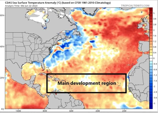
It’s an atmospheric loop of cause and effect that has left the waters in the so-called main development region of the Atlantic Ocean between Africa and the Caribbean as much as 6 degrees warmer than normal for mid-June.
That heat helped Tropical Storm Bret form June 19, and encouraged Tropical Depression Four to earn the name Cindy three days later. Both have since fizzled.
Scientists are generally still predicting a near-normal hurricane season despite the unusual conditions, but they are putting all bets on an awakening El Niño to knock down what otherwise could be a savage year for storms.
“El Niño will bring shear to the Atlantic basin and is the major check in this potentially very active Atlantic hurricane season,” said Jeff Weber, an atmospheric scientist at the National Center for Atmospheric Research.
“I would expect the unexpected as we sail through these uncharted waters of exceptional sea surface temperatures in a developing El Niño year.”
With Cindy’s formation, it’s the first time in the historical record that two named systems were born in the main development region in June, according to Bob Henson, a meteorologist and writer for Yale Climate Connections.
Climatologically, early-season tropical cyclones form closer to the shore in the Gulf of Mexico and the Caribbean or along the mid-Atlantic coast.
The waters in those regions are usually the necessary 80 degrees-plus in May, June and July to feed a fledgling tropical wave that has traveled inconspicuously from Africa, or conjure a tropical cyclone from a late-season cool front.
On average, a tropical wave exits the coast of Africa about every three to four days in June through October, spurred by a jet of east winds that stretch from Central Africa to the eastern Atlantic.
A small number of those waves become tropical cyclones.
An even smaller number become storms in the main development region before mid-August.
“Basically, the waters are too cold, too stable and too dry,” said Phil Klotzbach, a Colorado State University meteorologist and hurricane expert.
But this year, the Azores High is much weaker and displaced to the southwest of where it would be during an average year, noted Brian McNoldy, a senior research associate at the University of Miami’s Rosenstiel School of Marine, Atmospheric and Earth Science, in his Tropical Atlantic Update blog. That means less wind to cool the ocean surface and carry the Saharan dust, which reflects some of the sun’s heat as well as drying out the atmosphere.
This hurricane season the region, which has sea surface temperatures of about 82 degrees, is almost “ludicrously” hot, Klotzbach said. While there are some signs that the warming rate of the waters between Africa and the Caribbean will taper, they are “still so far above anything else it’s just problematic.”

“It’s like a football game. We are partway through the first quarter and the ocean is ahead,” said Hugh Willoughby, a distinguished research professor at Florida International University and former director of NOAA’s Hurricane Research Division.
Hurricanes that form in the main development region near the Cabo Verde Islands, formerly Cape Verde, can be the largest and most intense storms because they have so much warm open ocean to devour before reaching the Caribbean, Gulf of Mexico or U.S. east coast.
Category 5 Hurricane Irma in 2017 was a Cabo Verde storm, and so was 2004’s Hurricane Ivan, which reached Cat 5 strength three times before making landfall in Florida’s western Panhandle as a Category 3.
The notorious Hurricane Andrew of 1992 was also a Cabo Verde storm.
Andrew also formed during an El Niño — a climate pattern known for creating a tropical cyclone-killing wind shear.
The National Oceanic and Atmospheric Administration declared that El Niño had arrived in early June, but its effects on the atmosphere don’t turn on like a light switch.
It can take time for the wind shear to ramp up.
Klotzbach said he believes some burgeoning El Niño strength kept Bret from becoming a hurricane, although it got close with 70 mph sustained winds. A Category 1 hurricane begins at 74 mph.
Klotzbach predicts this year’s El Niño will be robust enough to counteract the extra warm waters, but forecasts are partly based on looking at what’s happened in past years with similar atmospheric setups. This year, there are no comparisons.
“Nothing looks like 2023 in the Atlantic,” Klotzbach said.
Bret was the third Atlantic storm of the year, following short-lived Tropical Storm Arlene on June 2 and an unnamed subtropical storm that formed Jan. 16.
The typical formation date of a season’s third storm is Aug. 3.
Daniel Gilford, a climate scientist with Climate Central, said a warmer world is an undercurrent to the oddities of the 2023 storm season with ocean temperatures, in general, rising at faster rates.
NOAA says the average rate of ocean temperature increase since 1981 has been 0.32 degrees per decade, which is twice as fast as previous decades.
“We already know we have all the fuel we need to start the fire.
The question is whether the fire can sustain itself, and that will be dependent on wind shear,” Gilford said about this hurricane season.
“Warmer sea surface temperatures are literally just more energy for a storm.”
CLICK HERE TO JOIN OUR WHATSAPP GROUP
CLICK HERE TO JOIN OUR WHATSAPP GROUP
CLICK HERE TO JOIN OUR WHATSAPP GROUP
CLICK HERE TO JOIN OUR WHATSAPP GROUP
CLICK HERE TO JOIN OUR WHATSAPP GROUP
CLICK HERE TO JOIN OUR WHATSAPP GROUP
Advertise with the mоѕt vіѕіtеd nеwѕ ѕіtе іn Antigua!
We offer fully customizable and flexible digital marketing packages.
Contact us at [email protected]


