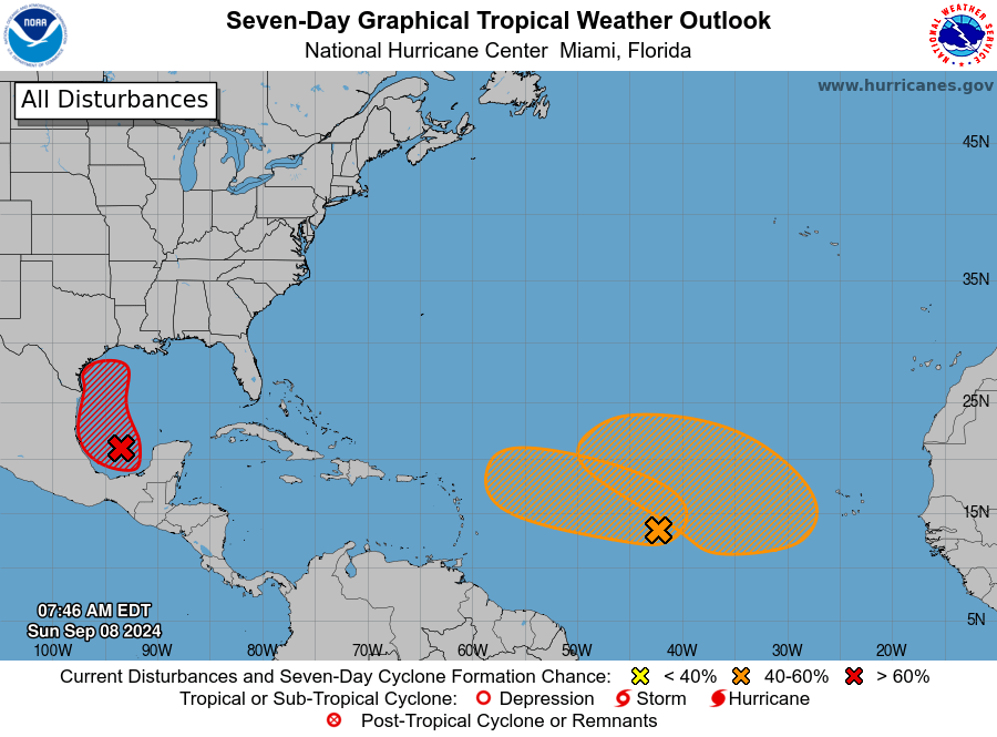
Central Tropical Atlantic (AL92): CLICK HERE TO JOIN OUR WHATS APP GROUP
Showers and thunderstorms linked to an elongated area of low pressure over the central tropical Atlantic are showing signs of organization.
Environmental conditions appear favorable for further development, with the possibility of a tropical depression forming while the system lingers over the central Atlantic through Monday.

It is expected to move westward at about 10 mph later in the week.
CLICK HERE TO JOIN OUR WHATS APP GROUP
- Formation chance through 48 hours: Low (40%)
- Formation chance through 7 days: Medium (60%)
Eastern and Central Tropical Atlantic:
A trough of low pressure located a few hundred miles southwest of the Cabo Verde Islands is generating disorganized showers and thunderstorms.
This system is expected to remain stationary for the next few days until interacting with a tropical wave moving off the African coast on Monday.
Afterward, conditions are expected to be conducive for gradual development, with a tropical depression possibly forming by mid to late week as the system moves west-northwestward.
CLICK HERE TO JOIN OUR WHATS APP GROUP
- Formation chance through 48 hours: Low (near 0%)
- Formation chance through 7 days: Medium (50%) CLICK HERE TO JOIN OUR WHATS APP GROUP
CLICK HERE TO JOIN OUR WHATS APP GROUP
CLICK HERE TO JOIN OUR WHATS APP GROUP
CLICK HERE TO JOIN OUR WHATS APP GROUP
Advertise with the mоѕt vіѕіtеd nеwѕ ѕіtе іn Antigua!
We offer fully customizable and flexible digital marketing packages.
Contact us at [email protected]


It’s good to be aware of weather conditions and developing systems, but sometimes it feels like the updates are being used as scare tactics.. Almost as if somebody vex when the predictions don’t play out as predicted.
Comments are closed.