


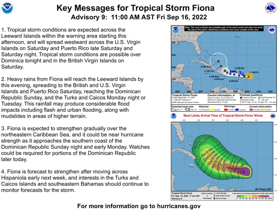
At 1100 AM AST (1500 UTC), the center of Tropical Storm Fiona was located near latitude 16.0 North, longitude 59.4 West. Fiona is moving toward the west near 14 mph (22 km/h).

A westward motion with a decrease in forward speed is expected through early Sunday,
followed by a turn toward the west-northwest and northwest Sunday and Sunday night. On the forecast track, the center of Fiona is expected to move across the Leeward Islands tonight, near or just south of the Virgin Islands and Puerto Rico Saturday into Sunday, and approach the southern coast of the Dominican Republic Sunday night and early Monday.

Data from Air Force Reserve and NOAA Hurricane Hunter aircraft indicate that maximum sustained winds are near 50 mph (85 km/h) with higher gusts. Gradual strengthening is forecast during the next few days.

Tropical-storm-force winds extend outward up to 140 miles (220 km) from the center.
The estimated minimum central pressure is 1005 mb (29.68 inches).

HAZARDS AFFECTING LAND
———————-

Key messages for Tropical Storm Fiona can be found in the Tropical Cyclone Discussion under AWIPS header MIATCDAT2 and WMO header WTNT42 KNHC and on the web at hurricanes.gov/text/MIATCDAT2.shtml.
WIND: Tropical storm conditions are expected across portions of the Leeward Islands within the warning area beginning this afternoon and will spread westward to the U.S. Virgin Islands on Saturday and across Puerto Rico late Saturday and Saturday night. Tropical storm conditions are possible on Dominica this evening or tonight and across the British Virgin Islands on Saturday.
RAINFALL: Fiona is forecast to produce the following rainfall totals:
Leeward Islands and Northern Windward Islands: 3 to 6 inches.
British and U.S. Virgin Islands: 4 to 6 inches
Puerto Rico: 4 to 8 inches with maximum totals of 12 inches, particularly across eastern and southern Puerto Rico.
Eastern Dominican Republic: 6 to 10 inches with maximum totals of 16 inches possible
Turks and Caicos: 4 to 8 inches These rains may produce flash and urban flooding, along with mudslides in areas of higher terrain, particularly southern and eastern Puerto Rico and the eastern Dominican Republic.
STORM SURGE: Localized coastal flooding will be possible along the coasts of the U.S. Virgin Islands and Puerto Rico in areas of onshore winds Saturday into Sunday.
SURF: Swells generated by Fiona are affecting the Leeward and
northern Windward Islands, and are expected to spread westward to
the Virgin Islands and Puerto Rico today. Swells will then reach the
northern coast of Hispaniola, the Turks and Caicos Islands, and the
southeastern Bahamas over the weekend. These conditions could cause
life-threatening surf and rip current conditions. Please consult
products from your local weather office.
NEXT ADVISORY
————-
Next intermediate advisory at 200 PM AST.
Next complete advisory at 500 PM AST.
Advertise with the mоѕt vіѕіtеd nеwѕ ѕіtе іn Antigua!
We offer fully customizable and flexible digital marketing packages.
Contact us at [email protected]


