Tropical Weather Outlook
NWS National Hurricane Center Miami FL
800 AM EDT Sat Sep 21 2024

For the North Atlantic...Caribbean Sea and the Gulf of Mexico:

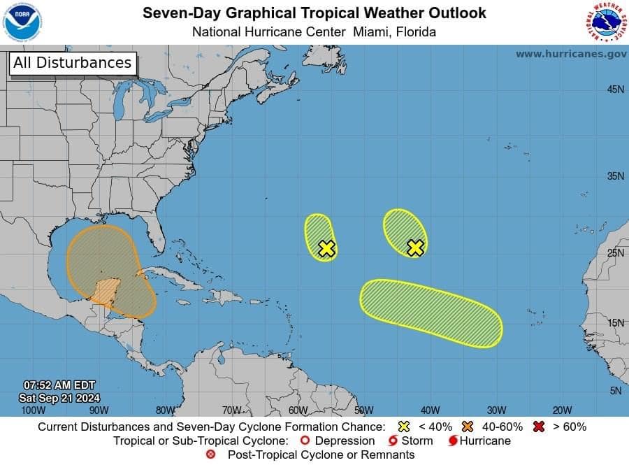
Central Subtropical Atlantic (Remnants of Gordon):
Strong upper-level winds continue to keep showers and thunderstorms
displaced away from the center of an area of low pressure (the
remnants of Gordon) located over one thousand miles southwest of the
Azores.  Significant development of this system is not expected
while it moves slowly northwestward over the central subtropical
Atlantic during the next couple of days.
* Formation chance through 48 hours...low...10 percent.
* Formation chance through 7 days...low...10 percent.

Central Subtropical Atlantic (AL96):
An area of low pressure located about 700 miles northeast of the
northern Leeward Islands is producing some disorganized shower and
thunderstorm activity.  Environmental conditions do not appear
conducive for significant development of this system during the next
couple of days while it drifts northwestward and then northward at
about 5 mph over the central or western subtropical Atlantic.
* Formation chance through 48 hours...low...10 percent.
* Formation chance through 7 days...low...10 percent.

Northwestern Caribbean Sea and Gulf of Mexico:
A broad area of low pressure is likely to form by the early to
middle part of next week over the northwestern Caribbean Sea and
the adjacent portions of Central America.  Thereafter, gradual
development of this system is possible, and a tropical depression
could form as the system moves slowly to the north or northwest
over the northwestern Caribbean Sea and across the Gulf of
Mexico through the end of next week.  Regardless of development,
this system is expected to produce heavy rains over portions of
Central America during the next several days.
* Formation chance through 48 hours...low...near 0 percent.
* Formation chance through 7 days...medium...60 percent.

Eastern and Central Tropical Atlantic:
A tropical wave is expected to move westward from the coast of
Africa on Sunday or Monday.  Gradual development of this system is
possible next week as it moves west-northwestward over the eastern
and central tropical Atlantic.
* Formation chance through 48 hours...low...near 0 percent.
* Formation chance through 7 days...low...30 percent.

$$
Forecaster Berg
Advertise with the mоѕt vіѕіtеd nеwѕ ѕіtе іn Antigua!
We offer fully customizable and flexible digital marketing packages.
Contact us at [email protected]


