CLICK HERE TO JOIN OUR WHAT’S APP GROUP

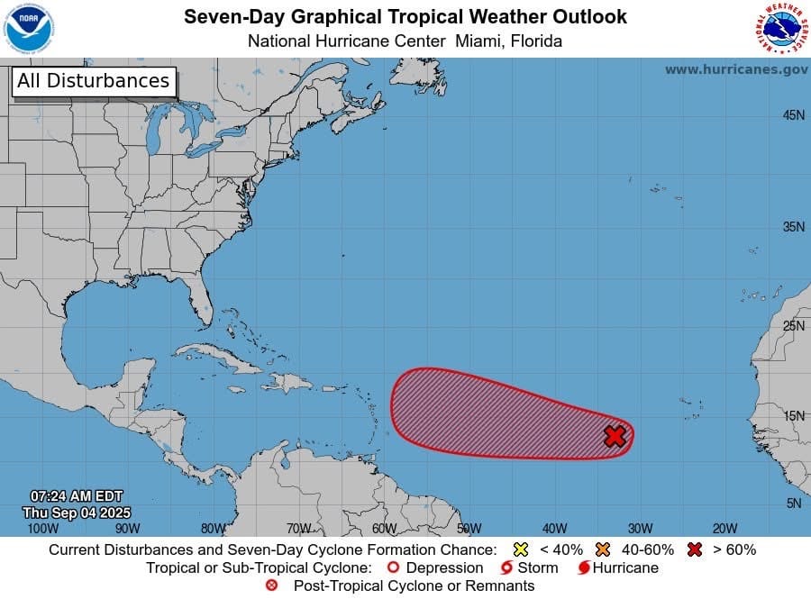
Tropical Weather Outlook Thursday September 4 2025
Showers and thunderstorms associated with a tropical wave located over the eastern tropical Atlantic several hundred miles west-southwest of the Cabo Verde Islands have started to consolidate and become slightly better organized.
Environmental conditions are conducive for development of this system during the next several days, and a tropical depression is likely to form late this week or this weekend over central tropical Atlantic while moving slowly toward the west-northwest at 5 to 10 mph.
The system is likely to move faster toward the west or west-northwest thereafter and reach the waters east of the Lesser Antilles by the middle of next week.
It has a medium (50 percent) chance of formation in the next 48 hours and a high (80 percent) chance of formation in the next 7 days.
Hurricanes.gov
CLICK HERE TO JOIN OUR WHAT’S APP GROUP
CLICK HERE TO JOIN OUR WHAT’S APP GROUP
CLICK HERE TO JOIN OUR WHAT’S APP GROUP
CLICK HERE TO JOIN OUR WHAT’S APP GROUP
CLICK HERE TO JOIN OUR WHAT’S APP GROUP
CLICK HERE TO JOIN OUR WHAT’S APP GROUP
CLICK HERE TO JOIN OUR WHAT’S APP GROUP
CLICK HERE TO JOIN OUR WHAT’S APP GROUP
CLICK HERE TO JOIN OUR WHAT’S APP GROUP
CLICK HERE TO JOIN OUR WHAT’S APP GROUP
CLICK HERE TO JOIN OUR WHAT’S APP GROUP
CLICK HERE TO JOIN OUR WHAT’S APP GROUP
Advertise with the mоѕt vіѕіtеd nеwѕ ѕіtе іn Antigua!
We offer fully customizable and flexible digital marketing packages.
Contact us at [email protected]


