


The government of Antigua and Barbuda has issued a Tropical Storm Watch for Barbuda and Anguilla.
The government of France has issued a Tropical Storm Watch for St. Barthelemy and St. Martin.
The government of Sint Maarten has issued a Tropical Storm Watch for Sint Maarten.

SUMMARY OF WATCHES AND WARNINGS IN EFFECT:
A Tropical Storm Watch is in effect for:
- Barbuda and Anguilla
- St. Barthelemy and St. Martin
- Sint Maarten
Interests elsewhere in the northern Leeward Islands, and the British and U.S. Virgin Islands should monitor the progress of Jerry.

For storm information specific to your area, please monitor products issued by your national meteorological service.

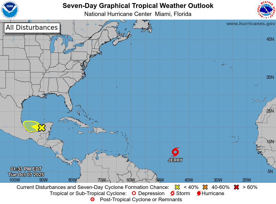
At 5:00 PM AST (2100 UTC), the center of Tropical Storm Jerry was located near latitude 12.0 North, longitude 46.4 West. Jerry is moving toward the west near 23 mph (37 km/h). A decrease in forward speed and a turn to the west-northwest is expected during the next couple of days. On the forecast track, the core of the system is expected to be near or to the north of the northern Leeward Islands late Thursday and Friday.
Maximum sustained winds are near 50 mph (85 km/h) with higher gusts.
Steady strengthening is forecast, and Jerry is expected to become a hurricane in a day or so.

Tropical-storm-force winds extend outward up to 140 miles (220 km) from the center.
The estimated minimum central pressure is 1003 mb (29.62 inches).

HAZARDS AFFECTING LAND
Key messages for Tropical Storm Jerry can be found in the Tropical Cyclone Discussion under AWIPS header MIATCDAT5 and WMO header WTNT45 KNHC.
WIND:
Tropical storm conditions are possible in portions of the northern Leeward Islands late Thursday and Friday, where Tropical Storm Watches have been issued.
RAINFALL:
On Thursday, 2 to 4 inches of rain are expected across the Leeward Islands due to Jerry. This rainfall brings a risk of flash flooding, especially in areas of higher terrain.
For a complete depiction of forecast rainfall and flash flooding associated with Priscilla, please see the National Weather Service Storm Total Rainfall Graphic, available at
hurricanes.gov/graphics_al5.shtml?rainqpf
SURF:
Swells generated by Jerry are expected to reach the Leeward Islands on Thursday. These swells are likely to cause life-threatening surf and rip current conditions. Please consult products from your local weather office.
A depiction of rip current risk for the United States can be found at:
hurricanes.gov/graphics_at5.shtml?ripCurrents
NEXT ADVISORY
Next intermediate advisory at 8:00 PM AST.
Next complete advisory at 11:00 PM AST.
$$
Forecaster Cangialosi
HAZARDS AFFECTING LAND
Key Messages:
Key messages for Tropical Storm Jerry can be found in the Tropical Cyclone Discussion under AWIPS header MIATCDAT5 and WMO header WTNT45 KNHC.
SURF:
Swells generated by Jerry are expected to reach the Leeward Islands on Thursday. These swells are likely to cause life-threatening surf and rip current conditions. Please consult products from your local weather office.
Advertise with the mоѕt vіѕіtеd nеwѕ ѕіtе іn Antigua!
We offer fully customizable and flexible digital marketing packages.
Contact us at [email protected]


Hopefully, this will just be a rain event for Antigua with no significant effects from the wind but still, take precautions for both since we all know how easily some areas of the island flood and the inevitably of APUA’s infrastructure failing in some communities.
The Hurricane Hunter planes are scheduled to fly tomorrow to take a closer look.
We need water but not the drana
Will school be closed 🤷🏽♀️🙏🏾
Be safe. Hopefully like all the others this one will pass us by
Hopefully it just gives us a little rain and cool breeze. Still everyone,please take it serious.
Even if the storm remains weak, proactive measures can prevent injuries, property damage, and disruption to daily life.
Comments are closed.