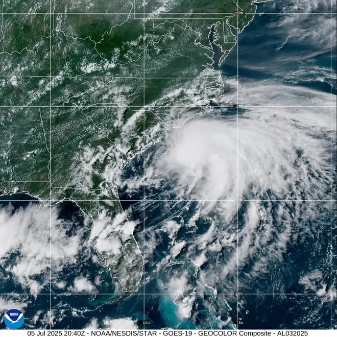
USA TODAY: Tropical Storm Chantal, which formed off the coast of South Carolina on Saturday, July 5, is expected to bring heavy rainfall across the coastal Carolinas Saturday night and Sunday, the National Hurricane Center said.
Heavy rainfall is expected across portions of the Carolinas, with flash flooding concerns, especially in urban areas, the NHC said in an update at 5 p.m. ET.
Earlier in the day, the center extended a tropical storm warning from the South Santee River in South Carolina, northward to Surf City, North Carolina. Tropical storm conditions within the warning area could start Saturday evening and continue through Sunday morning, the center said.
Also beginning later on Saturday, tropical storm conditions are possible in the watch area from Edisto Beach, North Carolina, to the South Santee River, S.C., according to the NHC.
Moderate flooding could occur east of Interstate 95, and that could prompt evacuations or rescues, said the National Weather Service office in Wilmington, N.C.
Tropical storm warning, watch for coastal Carolinas
Tropical Storm Chantal is expected to bring rainfall of two to four inches, with locally higher amounts of up to six inches, through Monday, July 7, the center said. The storm could also bring isolated tornadoes across parts of eastern South Carolina and eastern North Carolina Saturday night and into Sunday, the center said.
Chantal’s peak sustained winds are expected to reach just 50 mph, with potentially higher gusts before it makes landfall, the NHC warned. But to the benefit of the coastal Carolinas, most of the worst winds will remain out over the Atlantic Ocean.
At 5 p.m. ET Saturday, Chantal’s peak sustained winds were 45 mph and the storm was centered 95 miles southeast of Charleston and 165 miles south-southwest of Wilmington. Chantal has begun to move a little faster – 7 mph up from 3 mph earlier in the day.
Tropical Storm Chantal tracker

Coastal areas of South Carolina and southern North Carolina are expected to get wind gusts of 40 mph to 50 mph. “The strongest winds are expected near and to the east of where the storm makes landfall and can produce tree damage, localized power outages and some structural damage,” said AccuWeather Senior Meteorologist Tyler Roys.
Life threatening rip currents are possible at beaches from northeastern Florida to the Mid-Atlantic over the next few days, the NHC said.

The Atlantic hurricane season officially began on June 1 and will last through the end of November.
Active hurricane weather typically peaks between mid-August and mid-October.
Advertise with the mоѕt vіѕіtеd nеwѕ ѕіtе іn Antigua!
We offer fully customizable and flexible digital marketing packages.
Contact us at [email protected]


