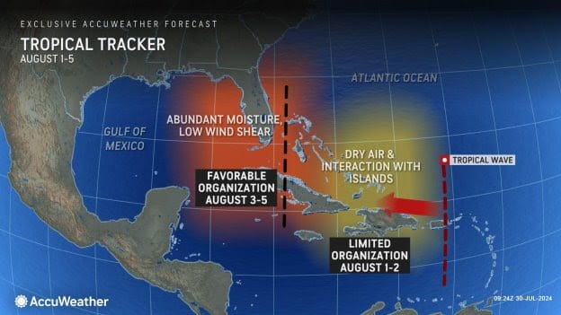
AccuWeather Global Weather Center – AccuWeather expert meteorologists say a developing tropical rainstorm in the Atlantic east of the Lesser Antilles could strengthen into a named storm later this week or weekend and potentially bring impacts to the United States this weekend or early next week.
“The tropical rainstorm is currently battling a harsh environment in a sea of dry air as it moves west across the Atlantic,” said AccuWeather Lead Hurricane Expert Alex DaSilva.
AccuWeather expert meteorologists refer to certain developing tropical threats as tropical rainstorms to raise awareness about the disruptions, damage and dangers that a system could pose before it becomes a named storm.
The tropical rainstorm is currently moving through an area that is not conducive for development, but it will soon move into an area with more favorable conditions. If this tropical rainstorm is able to intensify into a tropical storm, it would be named Debby.
“Dry air and wind shear ripped this tropical rainstorm apart. It’s struggling and essentially trying to reorganize from scratch today,” said AccuWeather Chief On-Air Meteorologist Bernie Rayno. “Right now, this tropical rainstorm has a 60 percent chance of strengthening into a named storm no sooner than this weekend or early next week.”
CLICK HERE TO JOIN OUR WHATS APP GROUP
The tropical rainstorm is moving through an area with very warm waters that can support development, but it will also encounter more disruptive wind shear over the next 24 hours. Wind shear is a change in direction or speed of winds at different heights in the atmosphere.
“Toward the end of this week, the tropical rainstorm will move into an area with fairly low wind shear and ample moisture, and that could allow some organization and strengthening,” said DaSilva.
“A major caveat is where the tropical rainstorm tracks. If it tracks north [or south] of the Greater Antilles rather than over the islands, then it will have a better chance to develop, as it will be removed from the towering mountains of Puerto Rico, Hispaniola and Cuba,” explained DaSilva.
CLICK HERE TO JOIN OUR WHATS APP GROUP
Mountains can disrupt the wind flow of a tropical feature and inhibit its wind intensity.
“Cuba and Hispaniola have very rugged mountainous terrain that tends to rip apart tropical threats. If this tropical rainstorm tracks across the islands it could weaken it and reduce the risk of intensification. However, if it survives, we could have big problems because conditions will be favorable for development,” said Rayno.
A tropical rainstorm that bounces westward, along the high mountains of the Greater Antilles, would likely struggle to organize. However, if the center stays away from the islands and their mountains, the waters are sufficiently warm enough to allow organization and strengthening.
CLICK HERE TO JOIN OUR WHATS APP GROUP
Should the storm track north of the big islands in the northern Caribbean later this week, it would more likely become a concern for the Bahamas and the East Coast of the U.S.
On the other hand, should the storm track just south of the big islands, it may be more concerning for the U.S. Gulf Coast over the weekend and into early next week.
Another factor will be a large area of high pressure over the central Atlantic, pushing the storm to the west, but only for so long. Later this weekend and into next week, steering winds should turn the storm to the northwest or north, near the U.S.
CLICK HERE TO JOIN OUR WHATS APP GROUP
Because of these conditions, families, businesses, officials, and emergency managers from the northern Caribbean to the Bahamas, as well as the U.S. Gulf Coast and southeast coast from Florida to the Carolinas should monitor this tropical threat closely.
By later this weekend to early next week, the tropical rainstorm could be turning northward along the U.S. Atlantic coast or if the storm tracks further to the south and west, it could be churning waters over the Gulf of Mexico, prior to moving onshore. This tropical threat could also create rough surf and dangerous rip currents.
CLICK HERE TO JOIN OUR WHATS APP GROUP
“This is a dynamic forecast situation, with small details on the tropical rainstorm comes together and evolves can have significant ramifications for the eventual track, intensity, and impacts of the storm,” said AccuWeather Chief Meteorologist Jon Porter. “We recommend people check back in with the AccuWeather forecast even more frequently than they typically would to stay updated.”
AccuWeather expert meteorologists are predicting an “explosive” hurricane season with 20-25 named storms and four to six direct impacts to the U.S. this year.
Hurricane Beryl is the latest example highlighting the concern that AccuWeather expert meteorologists and long-range experts have been warning about since March, with extremely warm waters increasing the odds of rapid intensification and devastating impacts at landfall.
As dry air diminishes and the effects of La Niña unfold late this summer and fall, AccuWeather expert meteorologists expect a flurry of tropical threats during the peak of hurricane season.
CLICK HERE TO JOIN OUR WHATS APP GROUP
CLICK HERE TO JOIN OUR WHATS APP GROUP
Advertise with the mоѕt vіѕіtеd nеwѕ ѕіtе іn Antigua!
We offer fully customizable and flexible digital marketing packages.
Contact us at [email protected]


