


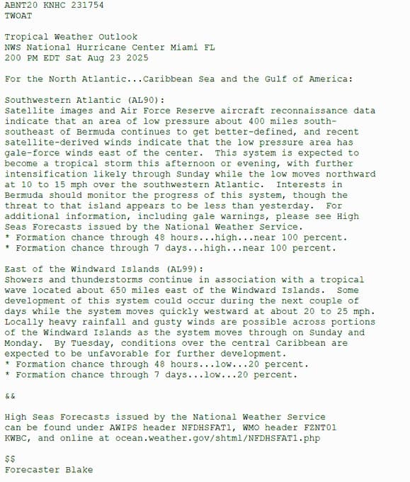
The National Hurricane Center (NHC) has reported two areas of concern in the Atlantic, one near Bermuda and another east of the Windward Islands, as the Caribbean braces for possible heavy rainfall and gusty winds.

Satellite images and reconnaissance data indicate that a low-pressure system roughly 400 miles southeast of Bermuda is becoming better defined, with gale-force winds detected east of the system’s centre. Meteorologists expect it to develop into a tropical storm later on Saturday, with intensification likely into Sunday. The system is moving northward over the southwestern Atlantic at 10 to 15 mph.
While Bermuda should monitor the disturbance, forecasters say the threat to the island has slightly decreased compared to the previous day. The likelihood of formation is near 100% over the next 48 hours and through the coming week.

Further east, showers and thunderstorms continue with a tropical wave approximately 650 miles east of the Windward Islands. Although development of this system is possible over the next few days, conditions are less favourable, with formation chances at 20% over both the next 48 hours and seven days. The system is moving quickly westward at 20 to 25 mph, with heavy rainfall and gusty winds expected across parts of the Windward Islands on Sunday and Monday.

High seas forecasts issued by the NHC provide further guidance for mariners and can be accessed through official channels including the National Weather Service’s website.
Forecaster Blake issued the report, highlighting the importance for residents and sailors in the region to remain vigilant as these weather systems evolve.

Advertise with the mоѕt vіѕіtеd nеwѕ ѕіtе іn Antigua!
We offer fully customizable and flexible digital marketing packages.
Contact us at [email protected]


