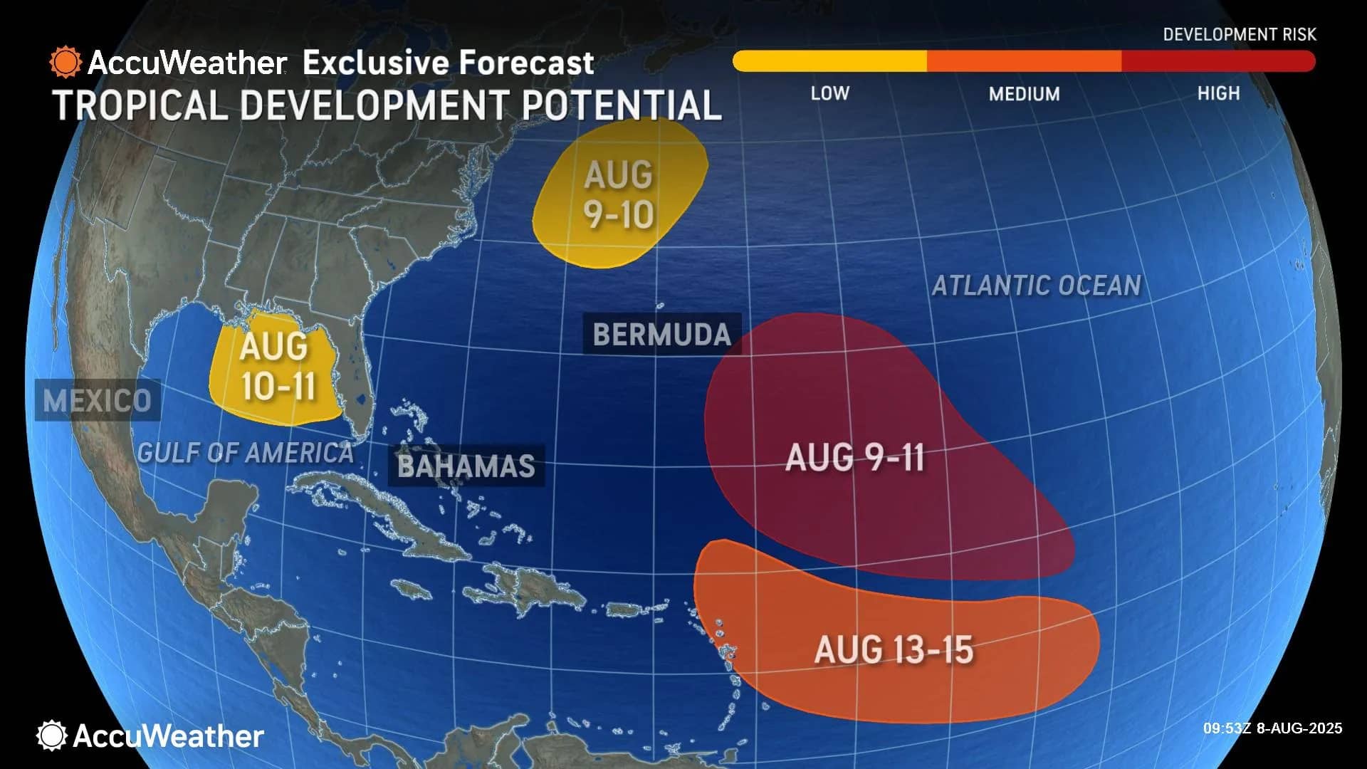
AccuWeather® Global Weather Center – Aug. 8, 2025 – As tropical wave activity ramps up off the coast of Africa and conditions in the Atlantic become more conducive for tropical development, AccuWeather® hurricane experts now forecast three to five named storms to form during the month of August.
The next names on the list of Atlantic basin storms this season are Erin, Fernand and Gabrielle.
AccuWeather® hurricane experts are currently monitoring four areas at risk of tropical development potential in the Atlantic basin: a low-risk area in the Gulf, a second off the East Coast of the United States, a medium-risk area in the Atlantic and a high-risk area in the Atlantic.
“A large plume of dust is moving off the African coast late this week. That dust plume will traverse the main development area of the Atlantic, where development is expected to occur through the middle of the week,” AccuWeather® Senior Meteorologist Chad Merrill explained. “Beyond the middle of next week, the dust train drops off significantly. We see an eventual favorable environment for thunderstorm clusters coming off the coast of Africa. The timeline for any potential impact to the Caribbean or the U.S. is Aug. 17 to 22.”
Merrill says the area with a high risk of tropical development potential in the Atlantic is not expected to pose a direct threat to the U.S. at this time.
“There is a high potential for low pressure to become a tropical depression or tropical storm in the central Atlantic. The timeline for development is this weekend into early next week,” Merrill explained. “At this time, there appears to be no direct threat to the U.S. from this low pressure, as it will get caught in the main steering flow of the jet stream and recurve somewhere near or east of Bermuda.”
The tropics were unusually quiet throughout August and into early September in 2024. AccuWeather® hurricane experts say the activity expected this August is normal, compared to historical averages.

“Tropical Storm Dexter has been our only named storm in the Atlantic so far this month. Erin will likely follow by early next week. This would likely evolve into the storm that recurves near or east of Bermuda, posing no direct threat to the U.S.,” Merrill explained. “Fernand would likely become the name of the next wave coming off the coast of Africa. AccuWeather® will be monitoring this tropical wave closely, since it may come within close proximity to the Caribbean and possibly the East Coast of the U.S. by mid- to late August.”
AccuWeather® hurricane experts say much of the central and eastern Gulf Coast, as well as the Atlantic coast from South Florida to the Outer Banks of North Carolina and Virginia Beach face a low risk of tropical rain and wind impacts at times through mid- to late August.
“Erin and Fernand will likely develop within the next two weeks,” Merrill said. “We typically see four named storms form in the Atlantic basin during the month of August. The tropical activity we’re seeing right now is normal, not unusual.”

AccuWeather® expert meteorologists say a surge of tropical moisture will bring frequent downpours that could trigger flash flooding across parts of the Southeast, Florida and the central and eastern Gulf Coast through Sunday.

The heaviest downpours are likely in the afternoon and evening hours this weekend.
Hazardous beach conditions this weekend
Regardless of tropical development, rough surf and strong rip currents are likely at times along much of the East Coast this week from Florida to Cape Cod in New England through the weekend.

People headed to Atlantic beaches are urged to exercise caution, learn the warning signs of rip currents and only swim in areas with lifeguards on duty.
AccuWeather 2025 U.S. Atlantic Forecast
AccuWeather® hurricane experts predict a dynamic and potentially volatile “above-average” Atlantic hurricane season this year, similar to last year’s historic and destructive season.
The AccuWeather® 2025 Atlantic Hurricane Season Forecast predicts 13 to 18 named storms, including seven to 10 hurricanes and three to five major hurricanes that reach Category 3 strength or higher on the Saffir-Simpson Hurricane Wind Scale.
A Category 3 hurricane has sustained winds between 111 and 129 miles per hour.

AccuWeather® is forecasting three to six direct impacts to the U.S. this year, which is the same range AccuWeather® forecast for the historic 2024 Atlantic hurricane season.
AccuWeather® was the first known source to issue an Atlantic hurricane season forecast in March.
AccuWeather® Lead Hurricane Expert Alex DaSilva issued an update in May, urging people, businesses, officials and emergency responders to prepare for an increased risk of flooding and tornado impacts reaching far inland after landfall, similar to last year.
Advertise with the mоѕt vіѕіtеd nеwѕ ѕіtе іn Antigua!
We offer fully customizable and flexible digital marketing packages.
Contact us at [email protected]


