The National Oceanic and Atmospheric Administration (NOAA) issued their mid-season outlook Wednesday. The latest release from NOAA started off with, “atmospheric and oceanic conditions have set the stage for an extremely active hurricane season that could rank among the busiest on record.
With the peak of hurricane season quickly approaching, NOAA’s National Weather Service urges everyone to know their risk; prepare for threats like damaging winds, storm surge and inland flooding from heavy rainfall; and to have a plan if asked to evacuate.”
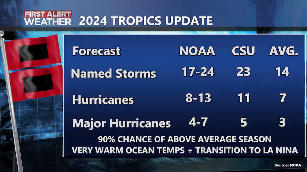
The latest outlook is calling for a 90% chance of an above average season. The earlier outlook issued in May was calling for an 85% chance of an above normal season.
The latest outlook did not increase or decrease the expected number of named storms, hurricanes, or major hurricanes. 17-24 named storms (tropical storm or stronger) are still expected with 8-13 of them being hurricanes and 4-7 major hurricanes (category 3 or higher).

The reason for the high confidence in expecting more storms than usual this year is because of warmer than normal ocean temperatures and La Nina forming in the Pacific.
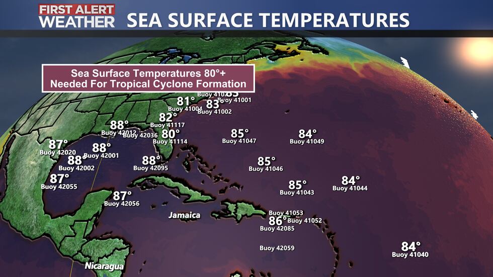
Ocean temperatures in the Atlantic Basin are well over the 80° F threshold for tropical cyclones to form. Many buoys are reporting 87-88° in the Gulf of Mexico, which is rocket fuel for these systems to form. These very warm ocean temperatures will continue into the peak of the season coming up in September.

We are also expecting a La Nina to form in the equatorial Pacific Ocean. La Nina means ocean temperatures in this part of the world are cooler than normal and can influence global weather patterns, including how much wind shear is present in the Atlantic Basin. When La Nina develops, vertical wind shear is lower in the Atlantic Basin, which makes it easier for tropical cyclones to form.
An active west African monsoon pattern will also persist the next few months. Monsoon season over western Africa will lead to waves of low pressure moving west, which will become the tropical waves that drift over open Atlantic waters and develop into tropical systems.
Another factor is a long lasting oscillation pattern in the Atlantic Ocean that has been in a warm phase since 1995.
“The hurricane season got off to an early and violent start with Hurricane Beryl, the earliest category-5 Atlantic hurricane on record,” said NOAA Administrator Rick Spinrad, Ph.D.
“Hurricane Beryl broke multiple long-standing records in the Atlantic basin, and we’re continuing to see the climatological hallmarks of an active season,” said Matthew Rosencrans, lead hurricane season forecaster with NOAA’s Climate Prediction Center.
We have most recently been impacted by Debby, which brought historic rainfall to Florida, Georgia, and the Carolinas.
Advertise with the mоѕt vіѕіtеd nеwѕ ѕіtе іn Antigua!
We offer fully customizable and flexible digital marketing packages.
Contact us at [email protected]


