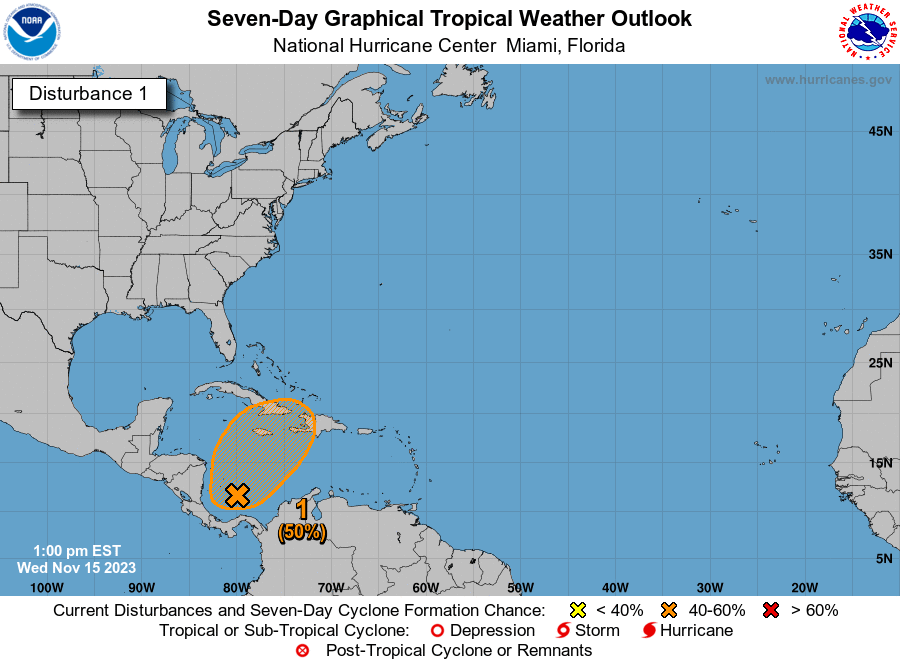
he US National Hurricane Center is monitoring two weather disturbances – one in the Southwestern Caribbean Sea and the other located offshore the Southeast coast of the United States.
The NHC in its latest update at 7 am on Wednesday said Disturbance One, which is a broad area of disorganised showers and thunderstorms over the southwestern Caribbean Sea, is associated with a trough of low pressure.
Environmental conditions appear marginally conducive for development of this system, and a tropical depression could still form by the weekend while the system begins moving northeastward across the western and central portions of the Caribbean Sea.
Interests in Jamaica, Cuba, Haiti, the Dominican Republic, the southeastern Bahamas, and the Turks and Caicos Islands should monitor the progress of this system.
Regardless of development, this system has the potential to produce heavy rains over portions of the Caribbean coast of Central America and the Greater Antilles through the weekend.
Disturbance One has a 30 per cent (low) chance of formation through 48 hours and a 50 per cent (medium) chance of formation through seven days.
Meanwhile for Disturbance Two, the NHC says a non-tropical area of low pressure is expected to develop near southern Florida along a surface trough over the next day or so.
This system is then forecast to move north-eastward near the Bahamas and offshore of the east coast of the US late this week and over the weekend.
Although development into a tropical cyclone appears
unlikely, this system is expected to produce gusty winds and heavy rains across portions of southern Florida, the Florida Keys, and the Bahamas during the next couple of days.
Disturbance Two has a 10 per cent (low) chance of formation through 48 hours and a 10 per cent (low) formation chance through seven days.
Original Story
The US National Hurricane Center is monitoring an area of disorganised showers and thunderstorms over the southwestern Caribbean Sea.
In an update Tuesday, the NHC said:
“A large area of disorganised showers and thunderstorms over the southwestern Caribbean Sea is associated with a broad trough of low pressure. Environmental conditions appear marginally conducive for development of this system, and a tropical depression could form late this week while the system begins moving northeastward across the western and central portions of the Caribbean Sea.
“Interests in Jamaica, Cuba, Haiti, the Dominican Republic, the southeastern Bahamas, and the Turks and Caicos Islands should monitor the progress of this system.
“Regardless of development, this system has the potential to produce heavy rains over portions of the Caribbean coast of Central America and the Greater Antilles through the end of this week.”
“Formation chance through 48 hours…low…30 percent.
“Formation chance through 7 days…medium…50 percent.”
The public is advised to monitor official weather channel platforms for the latest updates.
Advertise with the mоѕt vіѕіtеd nеwѕ ѕіtе іn Antigua!
We offer fully customizable and flexible digital marketing packages.
Contact us at [email protected]


