


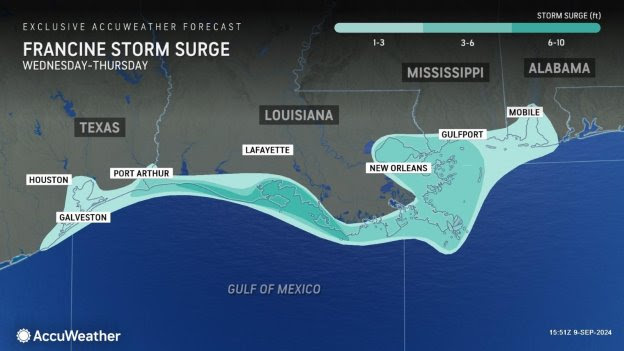
AccuWeather expert meteorologists say Francine could produce life-threatening storm surge and dangerous flash flooding across parts of coastal Louisiana, Texas and Mississippi as it approaches the Gulf Coast.

“The very shallow continental shelf makes the Gulf coast extremely vulnerable to storm surge,” said AccuWeather Lead Hurricane Expert Alex DaSilva. “AccuWeather is forecasting the threat of 6-10 feet of storm surge across parts of coastal Louisiana. Everyone needs to take storm surge watches and warnings seriously. Please listen to officials and follow evacuation orders. Storm surge is the deadliest threat from hurricanes, not the wind.”
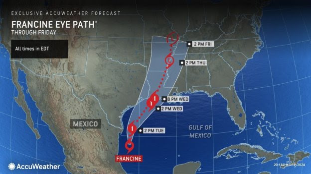
Tropical Storm Francine officially formed Monday morning in the extremely warm waters of the Gulf of Mexico. AccuWeather was the first known source to issue a forecast track and intensity forecast for this tropical threat Saturday afternoon, nearly 24 hours before the National Hurricane Center issued its first forecast track Sunday afternoon.
AccuWeather Chief Meteorologist Jon Porter said Francine is forecast to intensify into a Category 1 hurricane with maximum sustained winds of 74-95 mph on the Saffir-Simpson Hurricane Wind Scale before it makes landfall Wednesday.

“The extremely warm waters in the Gulf of Mexico act like rocket fuel for a developing storm. We’re concerned Francine will continue to intensify as it tracks north,” Porter explained “This storm is going to encounter disruptive wind shear, but it will also move through an area with very warm water and a lot of lifting in the atmosphere, which can help it intensify.”
There is a crucial window that AccuWeather expert meteorologists will closely monitor for the risk of rapid intensification between early Tuesday through Wednesday. While the wind shear will increase over the northern Gulf Coast as Francine approaches, near all-time record high sea surface temperatures and ocean heat content could allow for rapid strengthening prior to landfall.

“The powerful wind, flooding rainfall, storm surge, and rough surf from Francine could impact offshore oil and gas production, as well as port logistics along the Gulf coast,” said AccuWeather Director of Forecasting Operations Dan DePodwin. “Port Fourchon is a key port in the supply chain and processing of Gulf crude oil. Francine could disrupt production and logistics at Port Fourchon, which processes roughly 15 percent of America’s entire oil supply.”
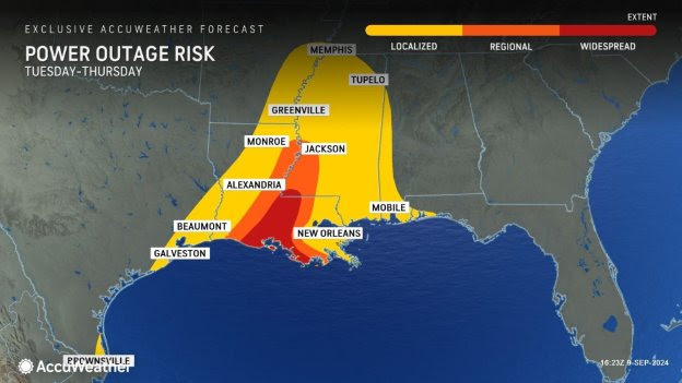
AccuWeather expert meteorologists are forecasting 60- to 80-mph wind gusts across parts of southern and central Louisiana. A zone of 80- to 100-mph wind gusts are expected in the area where Francine will make landfall. The AccuWeather Local StormMax™ is 115 mph.

Along with the threat of dangerous storm surge, Porter says people along the Gulf coast need to be prepared for the threat of flash flooding.
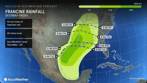
“This region is already soggy and saturated from heavy rainfall in the past few weeks. Flash flooding can happen very quickly,” warned Porter. “The risk of flash flooding will extend well inland as Francine tracks northeast toward the Mississippi Valley later this week.”
AccuWeather expert meteorologists are forecasting 4-8 inches of rainfall through Friday across parts of coastal Texas, coastal and central Louisiana, as well as western Mississippi. The AccuWeather Local StormMax™ is 24 inches.
DaSilva says people in the path of Francine should prepare for impacts from a hurricane that is strengthening in the final hours before landfall, similar to the impacts that were expected from Hurricane Beryl as it strengthened before landfall in Texas in July. There is a possibility that Francine could strengthen to a Category 2 hurricane with maximum sustained winds of 96-110 mph on the Saffir-Simpson Hurricane Wind Scale before it makes landfall.
AccuWeather expert meteorologists say Francine could potentially reach major hurricane status as a Category 3 hurricane with maximum sustained winds of 111-129 mph on the Saffir-Simpson Hurricane Wind Scale as it moves over pockets of extremely warm water in the Gulf.
“Thunderstorms are intensifying around the center of circulation. There is a lot of lightning around the center of circulation, which is another sign that this storm is intensifying,” DaSilva explained. “Hurricane-force winds can rip off roofs, topple trees, knock out power, and send dangerous debris flying through the air.”
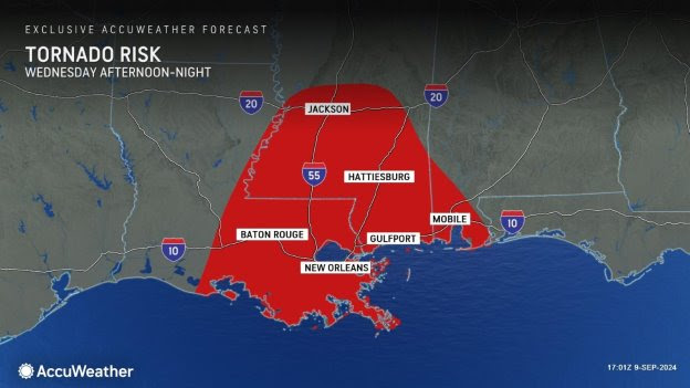
AccuWeather expert meteorologists say isolated tornadoes embedded in rainbands are also possible east of the storm track, including New Orleans and Baton Rouge, Louisiana, as well as Jackson, Mississippi and Mobile, Alabama.
On Monday afternoon, AccuWeather expert meteorologists upgraded Francine to a 2 on the AccuWeather RealImpact™ Scale for Hurricanes in the United States, which warns of moderate flooding, significant wind damage to small buildings and mobile homes, as well as tree damage, power outages and significant property damage from coastal inundation.
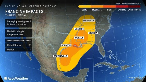
In contrast to the Saffir-Simpson Hurricane Wind Scale, which classifies storms by wind speed only, the AccuWeather RealImpact™ Scale is based on a broad range of important factors. In order to better communicate a more comprehensive representation of the potential impact of a storm on lives and livelihoods, the scale covers not only wind speed, but also flooding rain, storm surge and economic damage and loss. Some of these hazards, such as inland flooding and storm surge in many storms, result in more deaths and economic loss than wind.
Two additional tropical threats brewing
As AccuWeather expert meteorologists have been forecasting for the past few weeks, the tropical Atlantic is becoming more active here in early to mid-September. We are monitoring two additional tropical threats in the Atlantic basin that have a high risk for potential development later this week.
The first area of concern is located a few hundred miles west of Cape Verde and will slowly track westward across the open Atlantic over the upcoming days. From early to midweek, it will pose a high risk for development.
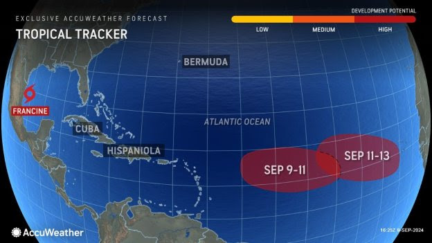
The second tropical wave is expected to emerge off Africa over the upcoming days and is projected to advance in a generally westward direction as the week progresses. This feature poses a high risk for development from mid to late week.
“It has been an unprecedented quiet stretch in the tropics without a named storm since mid-August. That streak is now over,” said AccuWeather Chief On-Air Meteorologist Bernie Rayno.
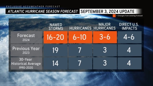
AccuWeather was the first known source to reduce the forecast for the number of named storms, hurricanes and major hurricanes expected during the 2024 Atlantic Hurricane season following the first Labor Day weekend without a named storm in decades.
AccuWeather is now forecasting;
> 16-20 named storms
> 6-10 hurricanes
> 3-6 major hurricanes
> 4-6 direct impacts to the United States
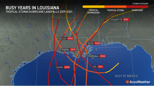
Hurricane history in Louisiana
The most recent hurricane to hit Louisiana was Ida in 2021. Between 2019 and 2021, Louisiana had eight tropical storms or hurricane landfalls, including major hurricanes Laura and Ida. In addition, Hurricane Sally tracked just east of the state’s boundaries in 2020, and Tropical Depression Nicholas passed through the southwest part of the state in 2021.
Two tropical rainstorms, previously tropical storms, also affected the state: Olga in 2019 and Beta in 2020.
Contractors imploded a high-rise office building in Lake Charles over the weekend that was left damaged and vacant for nearly four years after it took a direct hit from Category 4 Hurricane Laura in 2020.
Advertise with the mоѕt vіѕіtеd nеwѕ ѕіtе іn Antigua!
We offer fully customizable and flexible digital marketing packages.
Contact us at [email protected]


Me nah k bout Francine, I want to know what those two storm behind awe up to
will this be bigger than the LEADERSHIP STORM brewing in the UPP under Gisele leadership?
Comments are closed.