The government of Antigua has issued a Hurricane Warning for the islands of Antigua, Barbuda, Anguilla, Montserrat, St. Kitts, and Nevis. A Hurricane Watch has been issued for the British Virgin Islands.
The government of the Netherlands has issued a Hurricane Warning for the islands of Saba, St. Eustatius, and Sint Maarten.
The government of France has issued a Hurricane Warning for St. Martin and Saint Barthelemy.
A Hurricane Watch has been issued for Guadeloupe. A Hurricane Watch has been issued for the U.S. Virgin Islands, Puerto Rico, Vieques, and Culebra. The government of Barbados has issued a Tropical Storm Watch for Dominica.
A Hurricane Warning means that hurricane conditions are expected somewhere within the warning area. A warning is typically issued 36 hours before the anticipated first occurrence of tropical-storm-force winds, conditions that make outside preparations difficult or dangerous.
Preparations to protect life and property should be rushed to completion. A Hurricane Watch means that hurricane conditions are possible within the watch area.
A watch is typically issued 48 hours before the anticipated first occurrence of tropical-storm-force winds, conditions that make outside preparations difficult or dangerous.
A Tropical Storm Watch means that tropical storm conditions are possible within the watch area, generally within 48 hours. Interests in the Dominican Republic, Haiti, the Turks and Caicos Islands, and the southeastern Bahamas should monitor the progress of Irma.
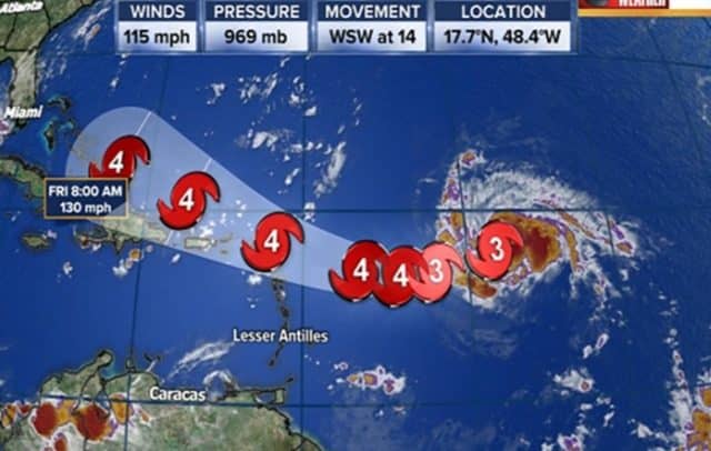
At 11a.m. the eye of Hurricane Irma was located near latitude 16.8 North, ongitude 53.3 West. Irma is moving toward the west-southwest near 14 mph (22 km/h). A turn toward the west is expected later today, followed by a west-northwestward turn late Tuesday.
On the forecast track, the center of Irma will move near or over portions of the northern Leeward Islands Tuesday night and early Wednesday. Maximum sustained winds are near 120 mph (195 km/h) with higher gusts.
Irma is a category 3 hurricane on the Saffir-Simpson Hurricane Wind Scale. Additional strengthening is forecast through Tuesday night. Hurricane-force winds extend outward up to 35 miles (55 km) from the center and tropical-storm-force winds extend outward up to 140 miles (220 km).
The estimated minimum central pressure based on data from a NOAA Hurricane Hunter aircraft is 944 mb (27.88 inches). The combination of a dangerous storm surge and large breaking waves will raise water levels by as much as 6 to 9 feet above normal tide levels along the coasts of the extreme northern Leeward Islands within the hurricane warning area near and to the north of the center of Irma.
Near the coast, the surge will be accompanied by large and destructive waves. Hurricane conditions are expected within the hurricane warning area by Tuesday night, with tropical storm conditions expected by late Tuesday.
Hurricane conditions are possible within the hurricane watch area by late Wednesday, with tropical storm conditions possible by early Wednesday.
Irma is expected to produce total rainfall accumulations of 3 to 6 inches across the Leeward Islands, with isolated maximum amounts of 10 inches across the northern Leeward Islands. These rainfall amounts may cause life-threatening flash floods and mudslides. Swells generated by Irma will affect the northern Leeward Islands during the next several days. These swells are likely to cause life-threatening surf and rip current conditions.
Advertise with the mоѕt vіѕіtеd nеwѕ ѕіtе іn Antigua!
We offer fully customizable and flexible digital marketing packages.
Contact us at [email protected]


