


Erin Moving West-Northwestward and Forecast to Rapidly Strengthen. Expected to Pass Near Or North of the Leeward Islands On Saturday

Hurricane Erin is expected to intensify rapidly as it moves west-northwest across the Atlantic, with forecasters warning it could reach major hurricane strength over the weekend.
At 17:00 AST (21:00 UTC) on Friday, the US National Hurricane Center (NHC) said Erin was located about 365 miles (585 km) east of the northern Leeward Islands, with maximum sustained winds of 75 mph (120 km/h). The storm is moving at 17 mph (28 km/h).

On its current track, the hurricane’s centre is forecast to pass near or just north of the northern Leeward Islands, the Virgin Islands and Puerto Rico between Saturday and Sunday.

A tropical storm watch remains in effect for Anguilla, Barbuda, St Martin, St Barthelemy, Saba, St Eustatius and Sint Maarten. Tropical storm conditions could reach these areas by early Saturday.
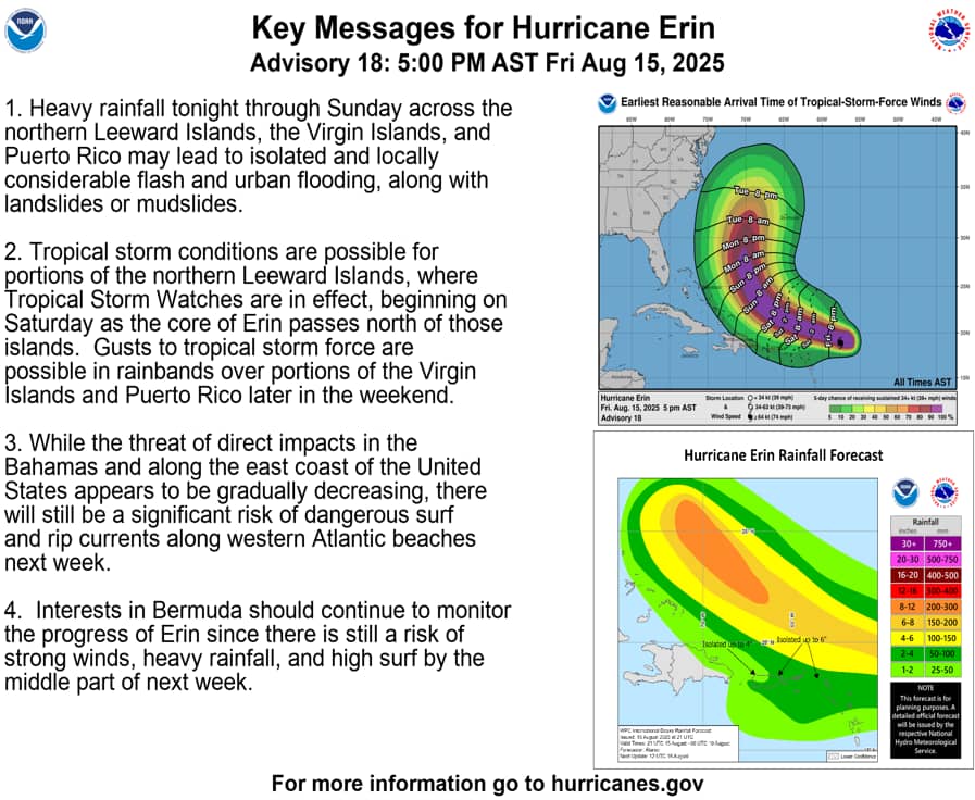
The NHC says outer rain bands could bring 2–4 inches (5–10 cm) of rain to the northern Leewards, Virgin Islands and Puerto Rico, with isolated areas receiving up to 6 inches (15 cm). This raises the risk of flash flooding, landslides and mudslides.

Swells generated by Erin are expected to create hazardous surf and life-threatening rip currents in the region from Saturday, spreading across the western Atlantic next week.
NOAA and Air Force Reserve Hurricane Hunter aircraft are scheduled to investigate the storm later on Friday. Forecasters say steady to rapid strengthening is expected in the coming days.

SUMMARY OF WATCHES AND WARNINGS IN EFFECT:
A Tropical Storm Watch is in effect for…
* Anguilla and Barbuda
* St. Martin and St. Barthelemy
* Saba and St. Eustatius
* Sint Maarten
A Tropical Storm Watch means that tropical storm conditions are
possible within the watch area, generally within 48 hours.
Interests elsewhere in the northern Leeward Islands, Virgin Islands,
and Puerto Rico, as well as in the Turks and Caicos and the
southeastern Bahamas should monitor the progress of Erin.
For storm information specific to your area, please monitor
products issued by your national meteorological service.
DISCUSSION AND OUTLOOK
———————-
At 500 PM AST (2100 UTC), the center of Hurricane Erin was located
near latitude 18.9 North, longitude 57.6 West. Erin is moving toward
the west-northwest near 17 mph (28 km/h). This motion is expected
to continue through the weekend with some decrease in forward
speed. On the forecast track, the center of Erin is likely to move
just north of the northern Leeward Islands, the Virgin Islands, and
Puerto Rico over the weekend.
Maximum sustained winds are near 75 mph (120 km/h) with higher
gusts. Steady to rapid strengthening is expected during the next
two to three days, and Erin is forecast to become a major hurricane
during the weekend. NOAA and Air Force Reserve Hurricane Hunter
aircraft are scheduled to investigate Erin this evening.
Hurricane-force winds extend outward up to 25 miles (35 km) from the
center and tropical-storm-force winds extend outward up to 115 miles
(185 km) mainly to the north of the center.
The estimated minimum central pressure is 993 mb (29.33 inches).
HAZARDS AFFECTING LAND
———————-
Key messages for Erin can be found in the Tropical Cyclone
Discussion under AWIPS header MIATCDAT5 and WMO header WTNT45 KNHC.
RAINFALL: The outer bands of Erin are expected to produce areas of
heavy rainfall tonight into Sunday across the northern Leeward
Islands, the Virgin Islands, and Puerto Rico. Rainfall totals of 2
to 4 inches, with isolated totals of 6 inches, are expected. This
rainfall may lead to isolated and locally considerable flash and
urban flooding, along with landslides or mudslides.
For a complete depiction of forecast rainfall and flash flooding
associated with Erin, please see the National Weather Service Storm
Total Rainfall Graphic, available at
hurricanes.gov/graphics_at5.shtml?rainqpf
WIND: Tropical storm conditions are possible within the watch
area by early Saturday.
SURF: Swells generated by Erin will begin affecting portions of the
northern Leeward Islands, the Virgin Islands and Puerto Rico by this
weekend, and will likely spread to the western Atlantic next week.
These swells are likely to cause life-threatening surf and rip
current conditions. Please consult products from your local weather
forecast office.
A depiction of rip current risk for the United States can be found
at: hurricanes.gov/graphics_at5.shtml?ripCurrents
NEXT ADVISORY
————-
Next intermediate advisory at 800 PM AST.
Next complete advisory at 1100 PM AST.
$$
Forecaster Beven
Advertise with the mоѕt vіѕіtеd nеwѕ ѕіtе іn Antigua!
We offer fully customizable and flexible digital marketing packages.
Contact us at [email protected]


Thank God the Storm is drifting away! The worst could’ve happen
Thanks for the update!
Thanks for the update!
Lord God, may the wings of your heavenly angels spread over these islands in path of storm/hurricane and protect them all in the name of Your Son Jesus Christ, Amen!
Lets jus continue to monitor it while we prepare for the unexpected.
Comments are closed.