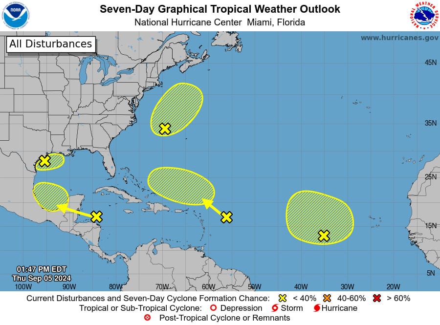
The National Hurricane Center (NHC) is tracking five tropical disturbances across the Atlantic.
While none of these systems currently pose an immediate threat, their potential for development warrants attention.
Each disturbance carries varying degrees of risk and could impact weather conditions in different regions.
It’s crucial to stay informed as these systems evolve, as even low-probability disturbances can escalate rapidly and affect coastal areas.
Here’s a detailed update on their current status and potential impacts:
• Northwest Gulf of Mexico: A broad low-pressure area near the northwestern Gulf is causing showers and thunderstorms. Upper-level winds are expected to become less favourable for development by late Friday and Saturday. Rainfall is anticipated for the northern Gulf Coast, with formation chances at 10% through both 48 hours and 7 days.
• Off the Coast of North Carolina: A low-pressure system several hundred miles off the North Carolina coast is showing increased organization with gale-force winds. It may develop some tropical or subtropical features in the next couple of days but is likely to lose its development potential as it moves into cooler waters by early Saturday. Formation chances are 30% through both 48 hours and 7 days.
• Eastern Tropical Atlantic: An elongated trough of low pressure, located roughly midway between the western coast of Africa and the Lesser Antilles, is producing minimal shower activity. Development is unlikely through the weekend, with chances at 0% through 48 hours and 20% through 7 days.
• Northwestern Caribbean Sea and Southwestern Gulf of Mexico: A tropical wave moving westward through the northwestern Caribbean and into the southwestern Gulf of Mexico is generating disorganized showers and thunderstorms. While significant development is not expected before it reaches Belize and the Yucatan Peninsula early Friday, gradual development could occur later in the weekend into early next week as it continues over the southwestern Gulf. Formation chances are 0% through 48 hours and 20% through 7 days.
• East of the Leeward Islands: A tropical wave located a few hundred miles east of the Leeward Islands is producing limited activity due to strong upper-level winds. Development is unlikely in the near term, but conditions might become more conducive for slow growth by early next week as the system moves into the southwestern Atlantic Ocean. Formation chances are 0% through 48 hours and 10% through 7 days.
Advertise with the mоѕt vіѕіtеd nеwѕ ѕіtе іn Antigua!
We offer fully customizable and flexible digital marketing packages.
Contact us at [email protected]


