


CLICK HERE TO JOIN OUR WHAT’S APP GROUP

AccuWeather hurricane experts are predicting a dynamic and potentially volatile Atlantic hurricane season this year, with several similarities to last year’s historic and destructive season.
“Everyone needs to start planning and preparing for hurricane season. Climatology, weather patterns, water temperatures, and many other factors all point to yet another active Atlantic hurricane season with more tropical storms and hurricanes forming, compared to the historical average,” AccuWeather Chief Meteorologist Jonathan Porter said. “We expect fewer named storms this year compared to last year. The total number of storms is not truly what defines a hurricane season; it is the impacts to land and populated areas. It only takes one landfall to create a devastating season.”
AccuWeather 2025 Atlantic Hurricane Season Forecast
The AccuWeather 2025 Atlantic Hurricane Season Forecast predicts 13-18 named storms this year, with 7-10 of those storms expected to strengthen into hurricanes.
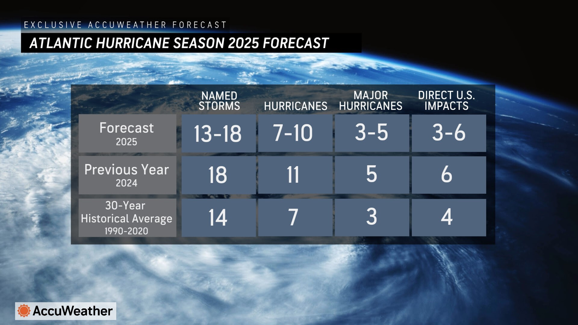
Three to five of those storms are predicted to strengthen into major hurricanes, which is a Category 3 hurricane or higher on the Saffir-Simpson Hurricane Wind Scale. Category 3 hurricanes have maximum sustained winds of 111-129 mph.
AccuWeather hurricane experts predict that three to six storms can directly impact the U.S. this year.
The other tropical storms and hurricanes that form this year could impact Central America, the Caribbean Islands, Bermuda, or they may remain out in the open Atlantic with no impacts to populated areas.

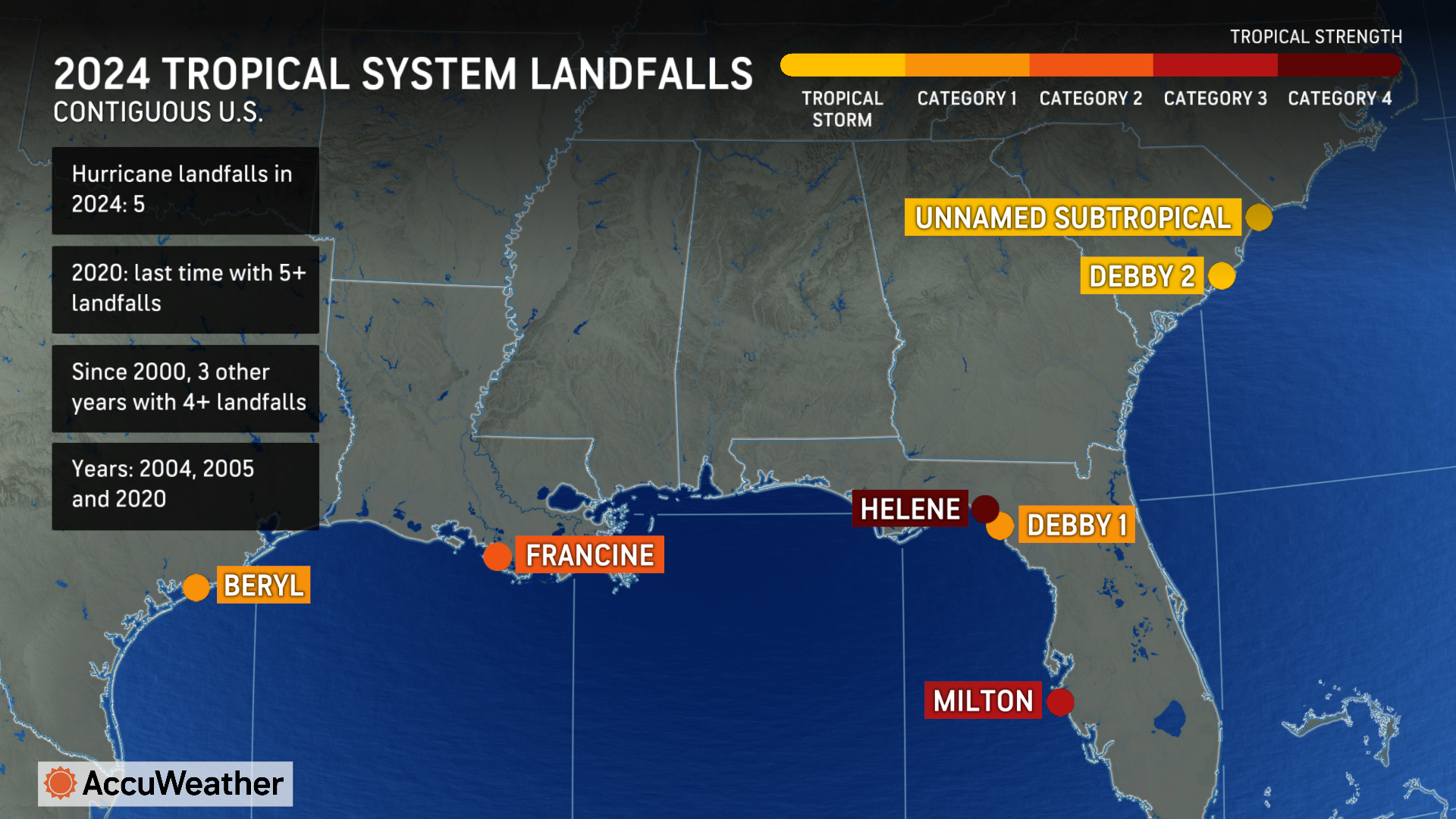
Five hurricanes and one unnamed subtropical storm made landfall in the U.S. in 2024. AccuWeather experts estimate the total damage and economic loss from tropical impacts in the U.S. last year reached a combined $500 billion.


“Extreme weather has taken a tremendous financial toll across the country,” Porter said. “Thousands of families and small businesses across America are still struggling to recover from weather disasters over the past year. We estimate that hurricanes, wildfires, winter storms, and impacts from extreme temperatures over the past 13 months have had a combined total damage and economic loss estimated at $693 billion to $799 billion.”
The Atlantic hurricane season officially starts on June 1 and runs through Nov. 30.
AccuWeather hurricane experts say early tropical development in May is possible this year due to exceptionally warm water temperatures expected across much of the Atlantic basin.
Five regions facing the greatest risk of direct impacts
AccuWeather hurricane experts say Texas, Louisiana, the western coast of Florida, North Carolina, and Atlantic Canada face a higher risk of direct impacts this hurricane season, compared to the historical average.
“Similar to last year, northern and eastern portions of the Gulf Coast and the Carolinas are at a higher-than-average risk of direct impacts this season,” AccuWeather Lead Hurricane Expert Alex DaSilva explained. “Atlantic Canada and the northeastern Caribbean are also at an increased risk of direct impacts.”
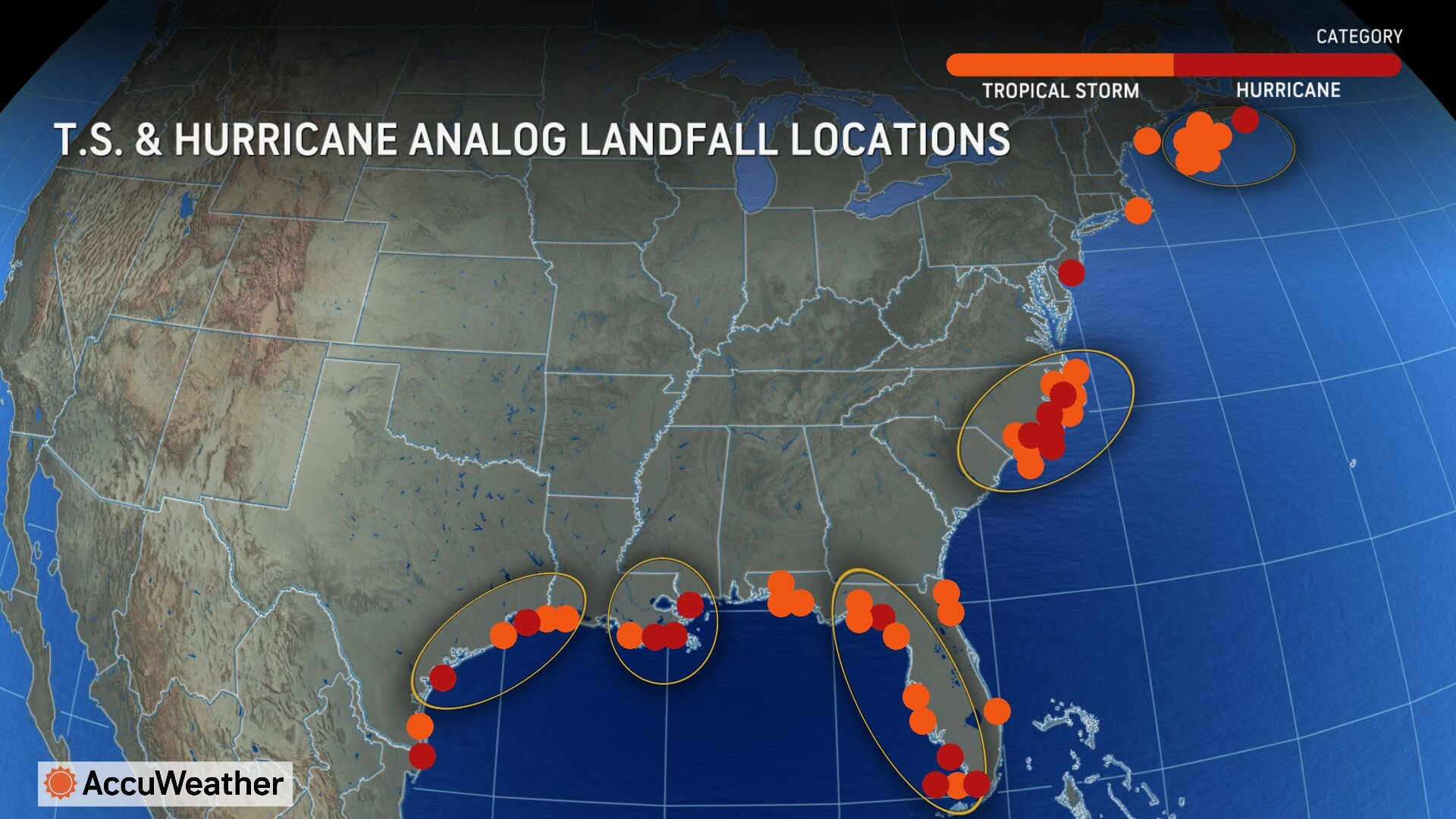
AccuWeather hurricane experts and long-range expert meteorologists review and analyze analog years, which are years in recent history when weather patterns were similar to what is happening now and conditions that are expected during the summer and fall months.
AccuWeather identified 12 analog years, with the 2017 and 2023 seasons being some of the most recent years with strong similarities.
Hurricane Harvey caused catastrophic flooding across Texas in August during the 2017 hurricane season. One month later, Hurricane Irma blasted parts of the Caribbean and much of Florida. Hurricane Maria devastated Puerto Rico and parts of the Caribbean in Sept. 2017 before taking aim at the southeastern U.S.
Hurricane Idalia slammed northern Florida in August of 2023 before bringing flooding rainfall and damaging wind gusts across the Southeast.
Keys to the forecast
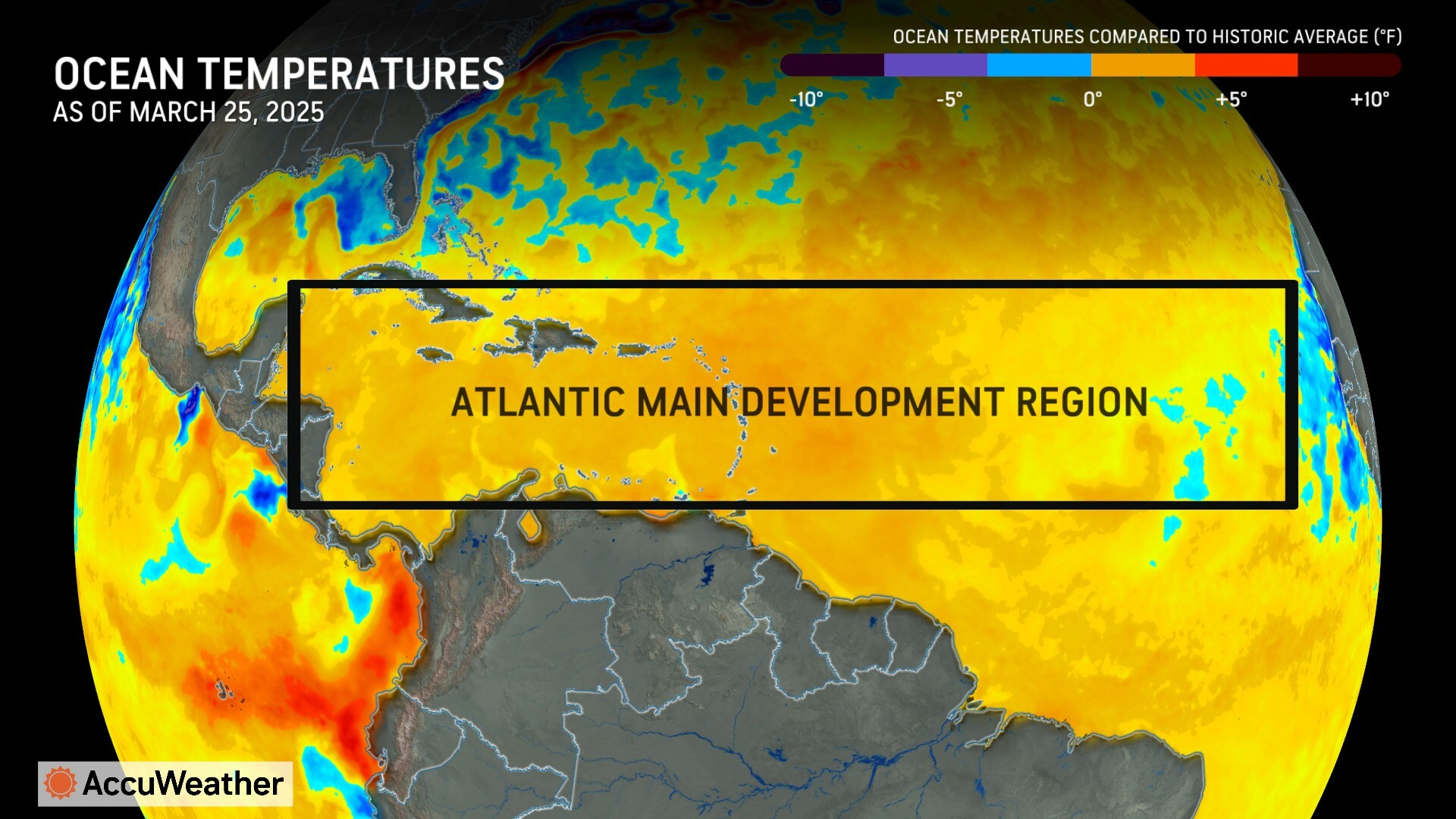
Water temperatures in the Atlantic, Caribbean and the Gulf are one of the biggest factors for tropical development.
AccuWeather hurricane experts say water temperatures across much of the Atlantic basin are well above historical average levels right now, and they are forecast to remain at elevated temperatures into the heart of the hurricane season.
The minimum temperature threshold for tropical system development is roughly 80 degrees Fahrenheit. Water temperatures in areas where most tropical storms and hurricanes form are expected to remain well above that threshold for the entirety of this hurricane season.
Warm waters extending to depths hundreds of feet below the surface provide additional energy for storms to develop and intensify.
“The threat of storms rapidly intensifying before they make landfall is a major concern again this year. Water temperatures at the surface and hundreds of feet deep are forecast to be well above the historical average throughout this hurricane season, providing extra fuel for storms to explode in intensity,” DaSilva said.
The rapid intensification of hurricanes in exceptionally warm waters near the coast has been a troubling trend with deadly outcomes in recent years. Hurricane Ian rapidly intensified from a Category 3 hurricane to a Category 5 with 160-mph sustained winds as it approached southwest Florida in September 2022. Catastrophic storm surge swept away coastal homes and businesses with water levels that crested near 18 feet in some places.
Four factors that could play a pivotal role
AccuWeather hurricane experts say the frequency, intensity and peak of tropical activity this year could be heavily influenced by the location of an area of high pressure over the open Atlantic, water temperatures off the western coast of Africa, water temperatures in the open Pacific Ocean, and dust that can impact storms that blow across Africa.
Water temperatures that can spawn a La Niña and El Niño near the equator in the eastern Pacific Ocean will also be important, since this regular climate phenomenon can have far-reaching effects that can help boost or suppress tropical activity in the Atlantic basin.
AccuWeather hurricane experts say neither La Niña nor El Niño are expected to be present during the first half of the hurricane season, but that could change by September, October, or November.
“A trend toward a La Niña could yield an active end to the season, while a trend toward El Niño could lead to an earlier end to the season,” DaSilva explained.
The Bermuda-Azores high is usually parked over the central Atlantic Ocean. Winds around this bubble of high pressure typically direct storms and hurricanes westward across the ocean before curving northward.

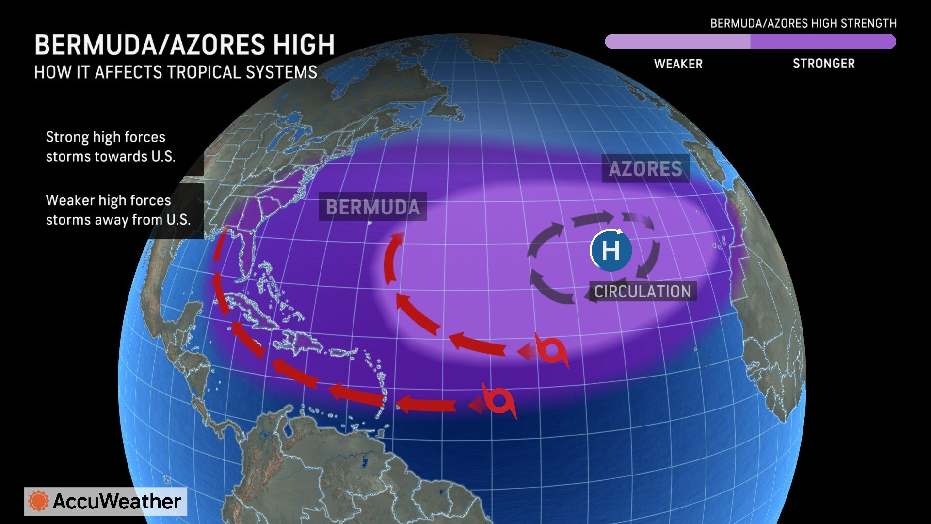
“The Bermuda-Azores high position can be offset farther south and east compared to average. This can favor a period of re-curving tropical systems northward in the western Atlantic when the high is weaker and another period of storms reaching the Caribbean and Gulf when the high is stronger,” DaSilva explained.
Depending on how the Bermuda-Azores high moves and strengthens throughout the season, it could have a big role influencing the track of tropical storms and hurricanes moving across the Atlantic.
Another area AccuWeather hurricane experts will monitor closely this hurricane season is off the western coast of Africa. Water temperatures in this region dipped to cooler levels compared to the historical average for a time last year, resulting in a phenomenon called “Atlantic Niña.” This contributed to a lull in tropical activity throughout August and into the start of September.
“It is certainly possible that we see lulls during the tropical season due to an enhancement of dry air if an Atlantic Niña develops,” DaSilva said. “If water temperatures heat up off the coast of Africa, we could see an enhancement of tropical development.”
AccuWeather hurricane experts say weather conditions across northern and central Africa may create more thunderstorms and clusters of showers that move westward over the Atlantic, known as tropical waves. DaSilva says an increase in tropical waves can result in an uptick in tropical storms and hurricanes forming in the Atlantic.
Another pivotal factor is whether there will be a presence or absence of massive clouds of dry and dusty air carried by the wind blowing from Africa over the Atlantic. Dry air and Saharan dust can limit tropical development as it moves over the Atlantic.

Saharan dust can remain suspended thousands of feet in the air when it reaches America, which can create hazy skies and vibrant sunsets for the Gulf Coast region.
Prepare for tropical threats far from the coast
AccuWeather hurricane experts say people in areas far from the Atlantic and Gulf coasts should prepare for potential tropical impacts this year.
Records show that tropical storms, tropical rainstorms, and hurricanes from the Atlantic basin have tracked across 34 states across the central and eastern U.S. since 1900.
The farthest west a tropical storm from the Atlantic basin has ever tracked was in New Mexico. Tropical storms and tropical rainstorms since 1900 have tracked as far inland as Oklahoma, Kansas, Iowa, Wisconsin and Michigan.
“We witnessed tragic examples of just how far inland the impacts from hurricanes and tropical storms can reach. Hurricane Beryl spun up more than 60 tornadoes along its nearly 1,200-mile-long path from the Texas coast to upstate New York,” DaSilva said. “Hurricane Helene slammed Florida with destructive wind and storm surge before it brought catastrophic flash flooding and destructive winds to the mountains of western North Carolina. Hurricane season preparedness is not just for coastal states. The history books show that hurricanes and tropical storms that track inland have caused devastating flooding and spun up tornadoes from New England and the Great Lakes to parts of the Plains, and occasionally even soaked parts of the Southwest.”
AccuWeather expert meteorologists warn that slower-moving tropical storms and hurricanes can unleash intense rainfall over the same areas for longer periods of time, increasing the risk of life-threatening flash flooding and damage to infrastructure.
How our warming climate is affecting hurricane season
AccuWeather Senior Meteorologist and Climate Expert Brett Anderson says air and water temperatures around the globe have been increasing over the past 50 years.
Anderson says the burning of fossil fuels is contributing to the greenhouse effect, which results in oceans absorbing and storing more excess heat.
“In just the past five years, we’ve seen water temperatures in the Atlantic, Caribbean, and the Gulf warm to levels never seen before in recorded history. That extra energy can supercharge tropical storms and hurricanes,” Anderson said. “Storms that rapidly intensify near the coast can leave people with less time to prepare and react before landfall. Rapidly intensifying storms can also complicate efforts to order evacuations, setup emergency shelters, and order contraflow along evacuation routes.”

In addition to concerns over rising sea levels and higher storm surge in coastal areas, Anderson says inland flooding is a growing concern in our warming climate.
“As air temperatures continue to rise, our atmosphere can hold more moisture. Hurricanes and tropical storms can bring tremendous amounts of rainfall hundreds of miles inland,” Anderson explained. “Intensifying rainfall rates can overwhelm streams, rivers, and aging drainage systems. Helene, Ian, Harvey, Florence, Imelda and Katrina are just a few of the notable hurricanes over the past 20 years that caused catastrophic flooding. A warming future could support even wetter hurricanes in the next 20 years.”
How AccuWeather is helping America prepare for hurricane season
Millions of people, thousands of businesses, and emergency officials across the country turned to AccuWeather for forecasts, alerts, and warnings during the historic and destructive 2024 Atlantic hurricane season.
AccuWeather was the first known source to warn of a supercharged hurricane season on Feb. 20, 2024. AccuWeather was also the first known source to issue an Atlantic hurricane season forecast on March 27, 2024, which warned of an explosive season that could have major impacts.
The AccuWeather 2024 Atlantic Hurricane Season forecast verified as one of the most accurate forecasts compared to government forecasts and all other sources.
“AccuWeather used push alerts through our app to warn hundreds of thousands of people about the risk for catastrophic flooding from Helene in the southern Appalachians. Our forecasts and alerts warned people of a possible flooding disaster from a once-in-a-generation storm. We know that strong wording, used by AccuWeather before any other known source, helped more families prepare and take action,” Porter said. “It’s critical that people prepare hurricane kits and review safety plans with their families before hurricane season starts on June 1. Everyone should remain vigilant and stay connected through the entire hurricane season, especially if they’re traveling to unfamiliar areas or places that are more vulnerable to flooding or storm surge when potential tropical threats are on the horizon.”
To help families, businesses, emergency officials and government leaders better prepare for approaching tropical storms and hurricanes, AccuWeather expert meteorologists developed the AccuWeather RealImpact™ Scale for Hurricanes in 2019.
The AccuWeather RealImpact Scale™ for Hurricanes is based on a variety of factors and hazards, including damaging winds, flooding rain, storm surge flooding and total damage and economic loss from all storm impacts, rather than simply wind. As a result, the unique and innovative scale communicates a more comprehensive representation of the potential impact and risk to lives and property.
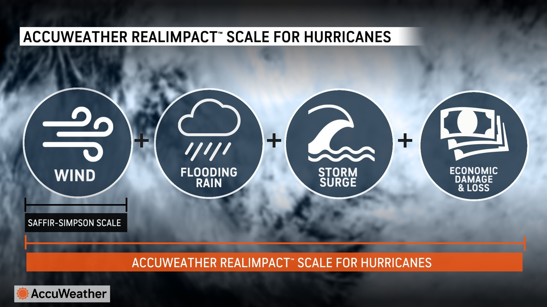
The Saffir-Simpson Hurricane Wind Scale has been used by meteorologists for decades and only classifies storms by wind speed. AccuWeather expert meteorologists say the Saffir-Simpson Hurricane Wind Scale is limited and outdated since it does not consider impacts beyond wind speed for rating hurricane strength.
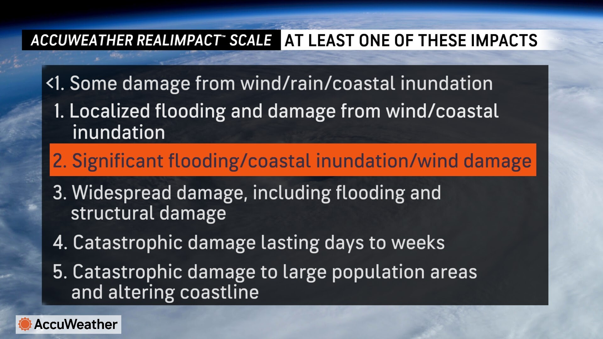
Storm surge, extreme rainfall, and flash flooding statistically cause more damage and deaths during tropical storms and hurricanes, compared to wind
CLICK HERE TO JOIN OUR WHAT’S APP GROUP
CLICK HERE TO JOIN OUR WHAT’S APP GROUP
CLICK HERE TO JOIN OUR WHAT’S APP GROUP
CLICK HERE TO JOIN OUR WHAT’S APP GROUP
Advertise with the mоѕt vіѕіtеd nеwѕ ѕіtе іn Antigua!
We offer fully customizable and flexible digital marketing packages.
Contact us at [email protected]


This such a dreadful season… SMH
I am hearing it going to a busy season.
Oh my… Hurricane season is near…. I can feel the pressure building up already.
I hope that it not going to be that bad.🙏
Comments are closed.