CLICK HERE TO JOIN OUR WHAT’S APP GROUP

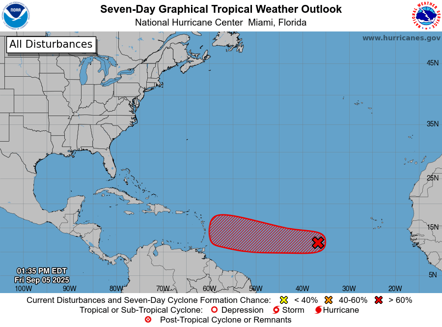
Disturbance 1: 70% Chance of Cyclone Formation in 7 Days
As of 2:00 PM EDT Fri Sep 5 2025…
Tropical Atlantic (AL91):
Shower and thunderstorm activity is currently limited and disorganized in association with a tropical wave over the central tropical Atlantic.
Although upper-level winds are generally favorable for development, environmental dry air is likely to limit development over the next couple of days.
However, a tropical depression could still form early next week as the system moves westward at around 10 mph across the central tropical Atlantic.
This system is likely to be near the Lesser Antilles by the middle to atter part of next week, and interests there should monitor its progress.
- Formation chance through 48 hours…medium…40 percent.
- Formation chance through 7 days…high…70 percent.
EARLIER INFORMATION STATEMENT BY MET OFFICE:
WOCA31 TAPA
Tropical Cyclone Information Statement
Antigua and Barbuda Meteorological Service
10:40 AM ECT Friday, September 05, 2025
…Tropical Cyclone Expected to Form…Interests in the Caribbean Should Monitor…
The Antigua and Barbuda Meteorological Service continues to closely monitor the progress of Tropical Disturbance AL91 located over the central tropical North Atlantic Ocean. The system is expected to become a tropical depression or storm early next week, as it moves in the direction of the Caribbean.
It is still unclear when AL91 will form or whether it will impact the region. The system continues to struggle, appearing weaker in satellite images than yesterday, with some of the more reliable models pulling back on its potential formation. Notwithstanding, environmental conditions appear favourable for further development. The risk of hazards from this disturbance is low, at this time. Interests in the Eastern Caribbean, including Leeward Islands and the British Virgin Islands, should be aware of potential hazardous weather and continue to monitor the progress of this disturbance. To be safe, residents are reminded to remain prepared for the remainder of the hurricane season.
At 8 AM ECT or 1200 UTC, the Tropical Disturbance AL91 was centred about 1743 miles east-southeast of Antigua and Barbuda and the Leeward Islands moving west at around 9 mph.
Maximum sustained winds remain near 25 mph with higher gusts. Formation chance through 48 hours is medium at 60 percent, and formation chance over seven days is high at 90 percent. This means development in the next 48 hours is more likely than not and is expected in seven days.
Please note that there are no tropical cyclone alerts, watches or warnings in effect for the area; however, an alert will likely be required in the next 24 hours.
The next update will be around 2 PM tomorrow, or sooner if required.
Forecaster Dale Destin
CLICK HERE TO JOIN OUR WHAT’S APP GROUP
CLICK HERE TO JOIN OUR WHAT’S APP GROUP
CLICK HERE TO JOIN OUR WHAT’S APP GROUP
CLICK HERE TO JOIN OUR WHAT’S APP GROUP
CLICK HERE TO JOIN OUR WHAT’S APP GROUP
CLICK HERE TO JOIN OUR WHAT’S APP GROUP
CLICK HERE TO JOIN OUR WHAT’S APP GROUP
CLICK HERE TO JOIN OUR WHAT’S APP GROUP
CLICK HERE TO JOIN OUR WHAT’S APP GROUP
CLICK HERE TO JOIN OUR WHAT’S APP GROUP
CLICK HERE TO JOIN OUR WHAT’S APP GROUP
CLICK HERE TO JOIN OUR WHAT’S APP GROUP
CLICK HERE TO JOIN OUR WHAT’S APP GROUP
Advertise with the mоѕt vіѕіtеd nеwѕ ѕіtе іn Antigua!
We offer fully customizable and flexible digital marketing packages.
Contact us at [email protected]


