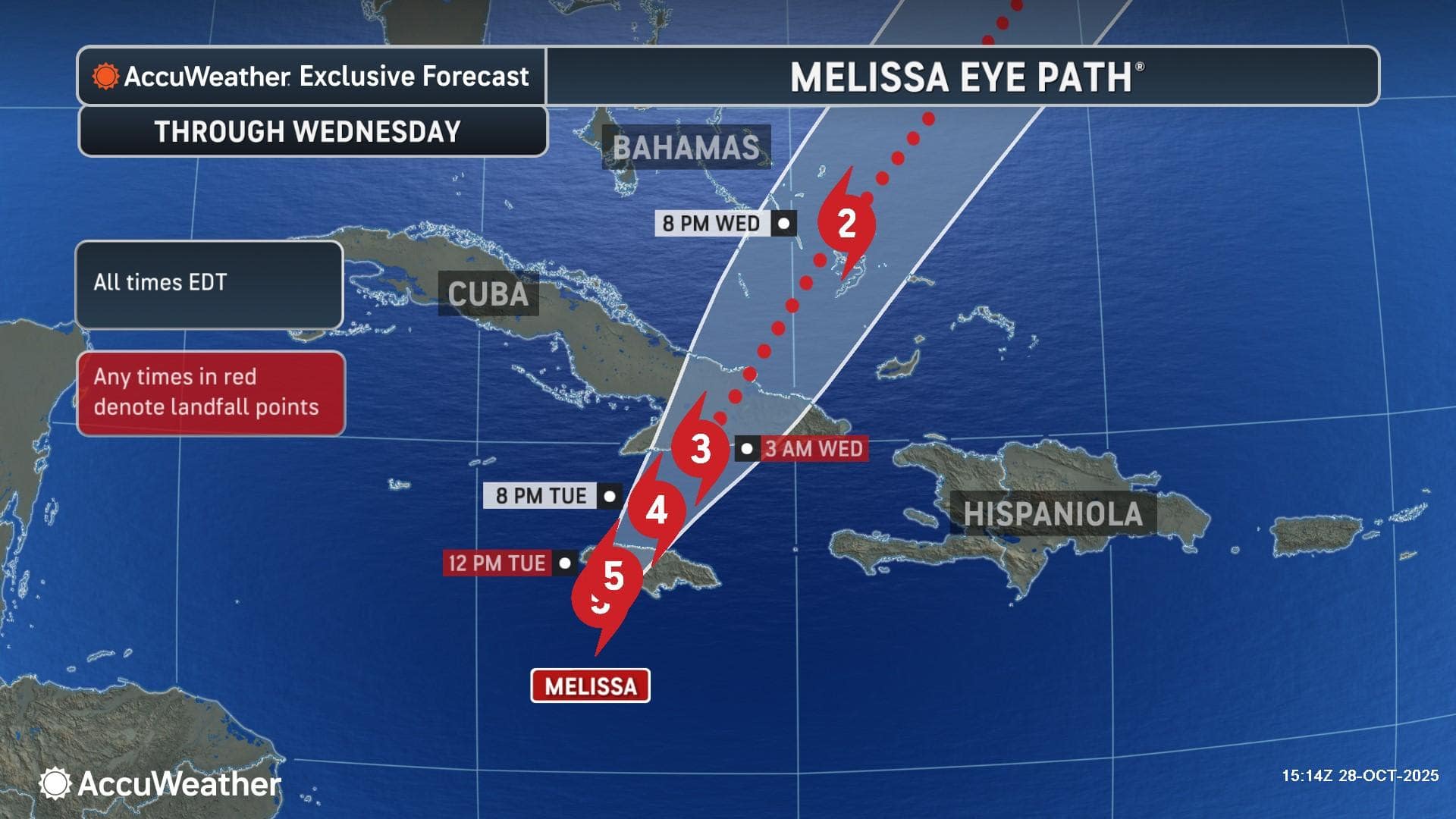
Devastating damage expected in Jamaica: Up to 18 feet of storm surge, catastrophic wind gusts up to 215 mph, and 3 feet of rainfall or more is possible across parts of Jamaica > Life-threatening impacts: Wind gusts in the eyewall of the hurricane will be comparable to an EF3 or EF4 tornado, which could last for hours in the hardest hit areas> Trek across the Caribbean: Melissa is forecast to make a second landfall as a major hurricane in Cuba late tonight or early Wednesday morning before moving into the Bahamas
AccuWeather® hurricane experts say Hurricane Melissa is now making landfall in Jamaica, bringing catastrophic winds, life-threatening storm surge, and torrential rainfall to the island. 
“The intense storm surge, extreme rain, and destructive winds can damage critical infrastructure across Jamaica. A catastrophic storm surge up to 18 feet is possible, just east of where the storm makes landfall. Key power plants, water treatment facilities, airports, shipping ports, and fuel terminals are all at risk of extensive damage or destruction in the hardest hit areas,” AccuWeather Chief Meteorologist Jonathan Porter said. “Especially in the areas where the core of the destructive winds travel, from south to north across the island, some communities may be unrecognizable given the level of catastrophic damage.”
AccuWeather® hurricane experts forecast wind gusts in Jamaica of 160-180 mph, with AccuWeather Local StormMax™of 215 mph. 
“Along the path of Melissa’s eyewall, wind gusts can be comparable to that of an EF-3 or EF-4 tornado, which can essentially level anything in its path,” AccuWeather Meteorologist Brandon Buckingham explained. “Wind gusts of this magnitude can last for hours, especially in areas that do not experience a brief break in the eye of the storm. This zone of catastrophic wind gusts can span 20-30 miles wide and extend from the southern shores to the northern shores of Jamaica.”
AccuWeather hurricane experts say the slow forward movement of Hurricane Melissa is extending the duration and amplifying the life-threatening impacts.
“People across Jamaica are facing the most extreme hurricane impacts the island has ever experienced in recorded history. The catastrophic wind speeds combined with the slow forward motion of this storm are a deadly and destructive combination,” AccuWeather Lead Hurricane Expert Alex DaSilva warned. “The uplifting motion forcing moisture-filled air over the mountains will squeeze out extreme amounts of rain. Some areas could see more than 3 feet of rainfall. Life-threatening flooding and mudslides will worsen as Melissa treks across the island. The destruction could be unlike anything people in Jamaica have seen before. The island has never taken a direct hit from a Category 4 or a Category 5 hurricane in recorded history.” 
“Melissa will go down in history as one of the slowest and one of the strongest October hurricanes on record in the Atlantic basin. Melissa surpassed the lowest minimum central pressure ever recorded for a hurricane this late in the season, another sign of just how intense this storm is,” DaSilva added.
“The significant danger posed by Melissa is made even worse due to its record-slow forward speed. An AccuWeather analysis of hurricanes since 1971 in the same area of the Caribbean as Melissa shows that Melissa’s average forward speed so far in this region is just 4.6 mph, which is the slowest on record,” AccuWeather Vice President of Forecasting Operations Dan DePodwin added. “Melissa is likely to tie the Labor Day storm of 1935 and Hurricane Dorian in 2019 for the highest sustained wind speed at landfall on record.”
The catastrophic impacts of the storm could complicate relief and recovery efforts across Jamaica. 
“This is a long-duration disaster. Conditions will be incredibly dangerous after the storm passes. Mudslides and washouts could leave many roads and bridges impassible for weeks or possibly months across Jamaica,” Porter said. “A coordinated international response will be needed to help hurricane survivors across the western Caribbean. Parts of Haiti and the Dominican Republic could face more flooding after days of heavy rainfall. The recovery may take up to a decade or longer in the hardest hit areas.”
“Roads and bridges could be washed away. Communities could be left completely cut off without power, communication, clean drinking water, or roads to get in and out,” DaSilva said. “Rescues will be virtually impossible during the peak of the storm impacts. Search, rescue, and recovery operations will be incredibly challenging and dangerous after the storm passes.”
Cuba, the Bahamas, and Bermuda now on alert
After Melissa crosses Jamaica, the storm will threaten Cuba with destructive winds, storm surge, and torrential rainfall.
“People in Cuba need to be prepared for a direct hit. Melissa is expected to make landfall in eastern Cuba with destructive wind gusts of 120-140 mph and 18-24 inches of rain,” Porter warned. “A destructive storm surge of 10-15 feet is possible along parts of the southeast coastline of Cuba. Melissa will bring damaging winds and torrential rainfall to the Bahamas after it passes over Jamaica and Cuba.” 
AccuWeather hurricane experts say Melissa will bring some wind and rain to Bermuda on Thursday afternoon and Friday.
Due to widespread life-threatening flooding rain, mudslides, strong winds and destructive storm surge, Melissa is a 5 for the western Caribbean on the AccuWeather RealImpact™ Scale for Hurricanes, a 3 for the Bahamas and a 1 for Bermuda.
Along the U.S. East Coast, onshore winds, coastal flooding, rough surf and beach erosion are possible this week, especially if Melissa expands in size.
Additional AccuWeather® Resources:
Category 5 Hurricane Melissa to unleash life-threatening catastrophe in Jamaica
Beyond Jamaica, Hurricane Melissa to blast Cuba, Bahamas before turning toward Bermuda
Advertise with the mоѕt vіѕіtеd nеwѕ ѕіtе іn Antigua!
We offer fully customizable and flexible digital marketing packages.
Contact us at [email protected]


