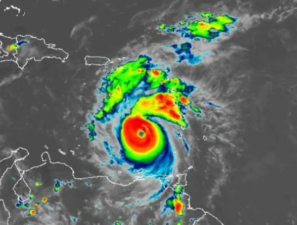
1100 PM AST Mon Jul 01 2024
…BERYL BECOMES A POTENTIALLY CATASTROPHIC CATEGORY 5 HURRICANE IN THE EASTERN CARIBBEAN… …EXPECTED TO BRING LIFE-THREATENING WINDS AND STORM SURGE TO JAMAICA LATER THIS WEEK…
SUMMARY OF 1100 PM AST…0300 UTC…INFORMATION
- Location: 13.8N 64.9W
- About 510 mi (825 km) ESE of Isla Beata, Dominican Republic
- About 840 mi (1355 km) ESE of Kingston, Jamaica
- Maximum Sustained Winds: 160 mph (260 km/h)
- Present Movement: WNW or 290 degrees at 22 mph (35 km/h)
- Minimum Central Pressure: 938 mb (27.70 inches)
WATCHES AND WARNINGS
Changes with this advisory: None.
Summary of Watches and Warnings in Effect:
- Hurricane Warning: Jamaica
- Tropical Storm Warning:
- South coast of Dominican Republic from Punta Palenque westward to the border with Haiti
- South coast of Haiti from the border with the Dominican Republic to Anse d’Hainault
Definitions:
- Hurricane Warning: Hurricane conditions are expected somewhere within the warning area, typically issued 36 hours before the anticipated first occurrence of tropical-storm-force winds.
- Tropical Storm Warning: Tropical storm conditions are expected somewhere within the warning area within 36 hours.
Interests elsewhere in the Cayman Islands and the remainder of the northwestern Caribbean should closely monitor the progress of Beryl. Additional watches or warnings may be required on Tuesday.
For storm information specific to your area, please monitor products issued by your national meteorological service.
DISCUSSION AND OUTLOOK
At 1100 PM AST (0300 UTC), the center of Hurricane Beryl was located near latitude 13.8 North, longitude 64.9 West, moving toward the west-northwest near 22 mph (35 km/h). This motion is expected to continue over the next couple of days, with Beryl’s center moving quickly across the southeastern and central Caribbean Sea tonight through Tuesday and passing near Jamaica on Wednesday.
NOAA Hurricane Hunters have recently reported maximum sustained winds of 160 mph (260 km/h), making Beryl a potentially catastrophic category 5 hurricane on the Saffir-Simpson Hurricane Wind Scale. Fluctuations in strength are likely over the next day or so, but Beryl is expected to remain a major hurricane as it moves through the central Caribbean and passes near Jamaica on Wednesday, with some weakening anticipated thereafter.
Hurricane-force winds extend outward up to 40 miles (65 km) from the center, and tropical-storm-force winds extend outward up to 125 miles (205 km). The minimum central pressure recently measured by the NOAA Hurricane Hunter dropsonde data is 938 mb (27.70 inches).
HAZARDS AFFECTING LAND
- Wind: Hurricane conditions are expected to reach Jamaica’s coast on Wednesday, with tropical storm strength winds arriving early Wednesday, making outside preparations difficult or dangerous.
- Tropical Storm Conditions: Expected in the warning area along the south coast of Hispaniola by late Tuesday.
- Storm Surge: Water levels could rise by 3 to 5 feet above normal tide levels in areas of onshore winds along the immediate coast of Jamaica, and by 1 to 3 feet above ground level along the southern coast of Hispaniola.
- Rainfall: Beryl is expected to produce 4 to 8 inches of rain in Jamaica, with localized maxima of 12 inches on Wednesday, potentially causing flash flooding. Outer bands may bring 2 to 6 inches of rain to portions of Hispaniola Tuesday into Wednesday.
- Surf: Large swells generated by Beryl will continue across the Windward and southern Leeward Islands for the next couple of days, reaching the southern coasts of Puerto Rico and Hispaniola late tonight into Tuesday, causing life-threatening surf and rip current conditions.
For a complete depiction of forecast rainfall and flash flooding associated with Hurricane Beryl, please see the National Weather Service Storm Total Rainfall Graphic at hurricanes.gov/graphics_at2.shtml?rainqpf.
Stay safe and keep monitoring updates from your local weather service.
Advertise with the mоѕt vіѕіtеd nеwѕ ѕіtе іn Antigua!
We offer fully customizable and flexible digital marketing packages.
Contact us at [email protected]


