


Barbuda Braces for Possible Tropical Storm Conditions from Erin

Barbuda is under a Tropical Storm Watch as Tropical Storm Erin moves closer to the northern Leeward Islands, with forecasters warning of heavy rain, strong winds, and dangerous seas this weekend.
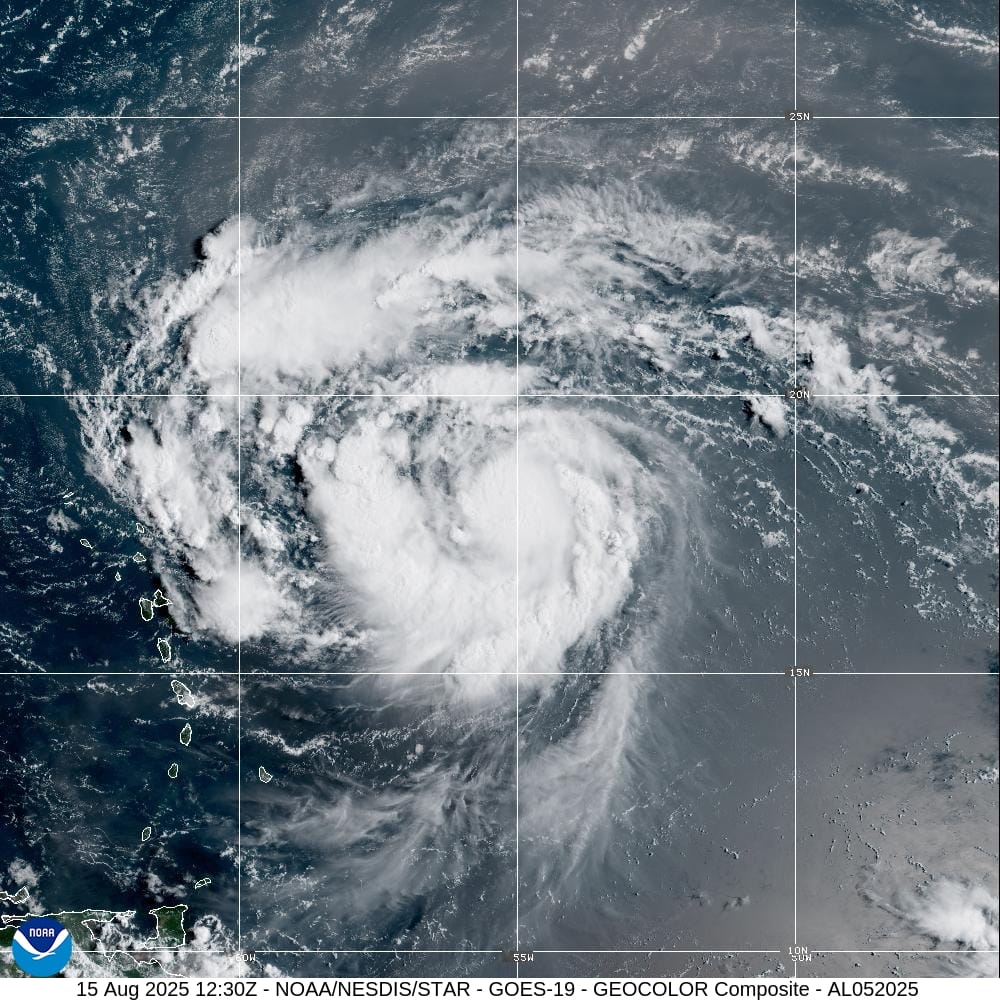
Tropical storm conditions could reach Barbuda by early Saturday, bringing sustained winds near 70mph (110km/h) and higher gusts if the storm strengthens as expected. Erin is forecast to become a hurricane later today and could reach major hurricane status by the weekend.

The system is expected to produce 2–4 inches of rain across the northernmost Leeward Islands, with isolated totals up to 6 inches. This rainfall could trigger flash flooding, landslides, and mudslides in vulnerable areas.

Hazardous swells and rip currents generated by Erin are also expected to affect the northern Leewards, posing life-threatening conditions for swimmers and small craft.
Residents are urged to secure property, avoid coastal waters, and follow guidance from the Antigua and Barbuda Meteorological Service.

SUMMARY OF WATCHES AND WARNINGS IN EFFECT:
A Tropical Storm Watch is in effect for…

- Anguilla and Barbuda
- St. Martin and St. Barthelemy
- Saba and St. Eustatius
- Sint Maarten
A Tropical Storm Watch means that tropical storm conditions are
possible within the watch area, generally within 48 hours.
Interests elsewhere in the northern Leeward Islands, Virgin Islands,
and Puerto Rico should monitor the progress of Erin.
For storm information specific to your area, please monitor
products issued by your national meteorological service.
DISCUSSION AND OUTLOOK
At 800 AM AST (1200 UTC), the center of Tropical Storm Erin was
located near latitude 18.1 North, longitude 55.2 West. Erin is
moving toward the west-northwest near 17 mph (28 km/h). This motion
is expected to continue into the weekend. On the forecast track, the
center of Erin is likely to move near or just north of the northern
Leeward Islands over the weekend.
Maximum sustained winds are near 70 mph (110 km/h) with higher
gusts. Steady strengthening is expected during the next few days
and Erin is forecast to become a hurricane later today, and it could
become a major hurricane by this weekend.
Tropical-storm-force winds extend outward up to 90 miles (150 km)
mainly to the northeast of the center.
The latest minimum central pressure estimated from NOAA Hurricane
Hunter aircraft data is 998 mb (29.47 inches).
HAZARDS AFFECTING LAND
Key messages for Erin can be found in the Tropical Cyclone
Discussion under AWIPS header MIATCDAT5 and WMO header WTNT45 KNHC.
RAINFALL: Tropical Storm Erin is expected to produce areas of heavy
rainfall beginning late Friday and continuing through the weekend
across the northernmost Leeward Islands, the U.S. and British Virgin
Islands, as well as southern and eastern Puerto Rico. Rainfall
totals of 2 to 4 inches, with isolated totals of 6 inches, are
expected. This rainfall may lead to isolated flash and urban
flooding, along with landslides or mudslides.
For a complete depiction of forecast rainfall and flash flooding
associated with Tropical Storm Erin, please see the National Weather
Service Storm Total Rainfall Graphic, available at
hurricanes.gov/graphics_at5.shtml?rainqpf
WIND: Tropical storm conditions are possible within the watch
area by early Saturday.
SURF: Swells generated by Erin will begin affecting portions of the
northern Leeward Islands, the Virgin Islands and Puerto Rico by this
weekend, and will likely spread to the western Atlantic next
week. These swells are likely to cause life-threatening surf and
rip current conditions. Please consult products from your local
weather forecast office.
Advertise with the mоѕt vіѕіtеd nеwѕ ѕіtе іn Antigua!
We offer fully customizable and flexible digital marketing packages.
Contact us at [email protected]


Hope it doesn’t impact any land
Comments are closed.