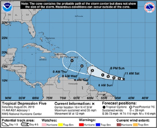
Dorian is moving toward the west near 13 mph (20 km/h), and this motion should continue on Sunday, followed by a motion toward the west-northwest on Monday and Tuesday.
On the forecast track, Dorian is expected to be near the central Lesser Antilles late Monday or early Tuesday.
Based on this forecast, residents across Barbados have been urged to closely monitor the approach of the storm.
Director of the Department of Emergency Management (DEM), Kerry Hinds, is reminding residents to listen to advisories issued through the Met Office, DEM and the Barbados Government Information Service.
Hind is urging the public to ensure that they have their emergency kits, batteries, water, canned goods, and other emergency supplies on hand.
People should also have emergency plans and important documents close by.
The Director further stressed that persons should also ensure the safety of their elderly relatives and be aware of the emergency shelters closest to them.
“Don’t wait until it is too late to take precautions. Please remember, it only takes one system to cause disruption,” Hinds said.
A Tropical Storm Watch means that tropical storm conditions are possible within the watch area, generally within 48 hours.
Additional watches will likely be issued later on Sunday for portions of the Windward and Leeward Islands. Elsewhere, interests in Puerto Rico and Hispaniola should monitor the progress of Dorian.
Advertise with the mоѕt vіѕіtеd nеwѕ ѕіtе іn Antigua!
We offer fully customizable and flexible digital marketing packages.
Contact us at [email protected]


