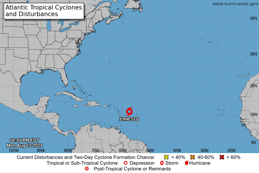
Forecaster Dale Destin:Good news! At 8 pm, Ernesto is back on a westerly track at 28 mph. Also, it remains very disorganised.

Tropical Storm Ernesto Update
CLICK HERE TO JOIN OUR WHATS APP GROUP
As of 8:00 PM AST (0000 UTC), the center of Tropical Storm Ernesto is located near latitude 16.0 North, longitude 58.5 West. The storm is moving westward at approximately 28 mph (44 km/h).
A slight decrease in speed is anticipated, with the storm expected to track westward to west-northwestward over the next couple of days. On this path, Ernesto is forecasted to pass through the Leeward Islands late tonight or Tuesday and approach the U.S. and British Virgin Islands and Puerto Rico by Tuesday evening. It is then expected to turn northward over the western Atlantic.
Maximum sustained winds are around 40 mph (65 km/h), with higher gusts. Gradual strengthening is forecasted in the coming days. Tropical-storm-force winds extend up to 60 miles (95 km) from the storm’s center. The estimated minimum central pressure is 1009 mb (29.80 inches).
CLICK HERE TO JOIN OUR WHATS APP GROUP
Ernesto is predicted to produce 4 to 6 inches of rain over parts of the Leeward and Virgin Islands. In Puerto Rico, 3 to 6 inches of rain is expected, with isolated maximum amounts up to 10 inches. Elsewhere in the Caribbean, the Windward Islands may receive 1 to 4 inches of rain, and eastern Hispaniola may receive 2 to 4 inches through Friday morning.
Tropical storm conditions are expected to impact the Leeward Islands late tonight or early Tuesday, and these conditions will begin affecting the Virgin Islands and Puerto Rico by Tuesday evening.
CLICK HERE TO JOIN OUR WHATS APP GROUP
A storm surge could raise water levels by 1 to 3 feet along Puerto Rico’s eastern coast from San Juan to Guayama, including the islands of Culebra and Vieques, as well as in the U.S. Virgin Islands, including St. Thomas, St. John, and St. Croix. Similar surges are expected in the British Virgin Islands, likely accompanied by large and destructive waves.
Swells generated by Ernesto may begin affecting portions of the Leeward Islands starting late tonight, potentially causing life-threatening surf and rip current conditions.
For detailed forecasts and updates, refer to the National Weather Service and relevant local authorities.
CLICK HERE TO JOIN OUR WHATS APP GROUP
CLICK HERE TO JOIN OUR WHATS APP GROUP
CLICK HERE TO JOIN OUR WHATS APP GROUP
CLICK HERE TO JOIN OUR WHATS APP GROUP
CLICK HERE TO JOIN OUR WHATS APP GROUP
Advertise with the mоѕt vіѕіtеd nеwѕ ѕіtе іn Antigua!
We offer fully customizable and flexible digital marketing packages.
Contact us at [email protected]


disorganized like UPP!!!Since the convention the partypoop cannot ketch itself. Many DISGRUNTLED with the process and outcome!!! The SURPRISING DEPARTURE of Mr. Smith! The exposure of the cult-like setup aka the “leadership within the leadership”. Pringle can’t stand them, so much so he REFUSE TO SHOW UP to any helping sessions with “dem day”
Privy Council Loser Lawyer demanding LOYALTY TESTS for the shirtless winkup clown, the snake, and the gunman.
richard run gone way with he JAMICAN WIFE to get a break from gizzy poo and loveLIE
disorganized, CHAOTIC, cesspool, TOXIC UPP!!!!
@pringle need fu get back a kindergarten ,what are you,Tanny Rose incarnated? For goodness sake,the post was about the weather and you dragged it down into the dirt where you dwell. Simply confirming my description of the nasty,mudslinging, illiterate, bad-minded Labourites.
You want to see disorganized? Check ALP. The only reason ALP appears settled is the botox- faced dictator who looks like it’s painful to smile,bullying and dictating what happens. No one dares oppoose him.
This government WILL fall. It’s just a matter of time. Then maybe we will be spared the likes of you
Comments are closed.