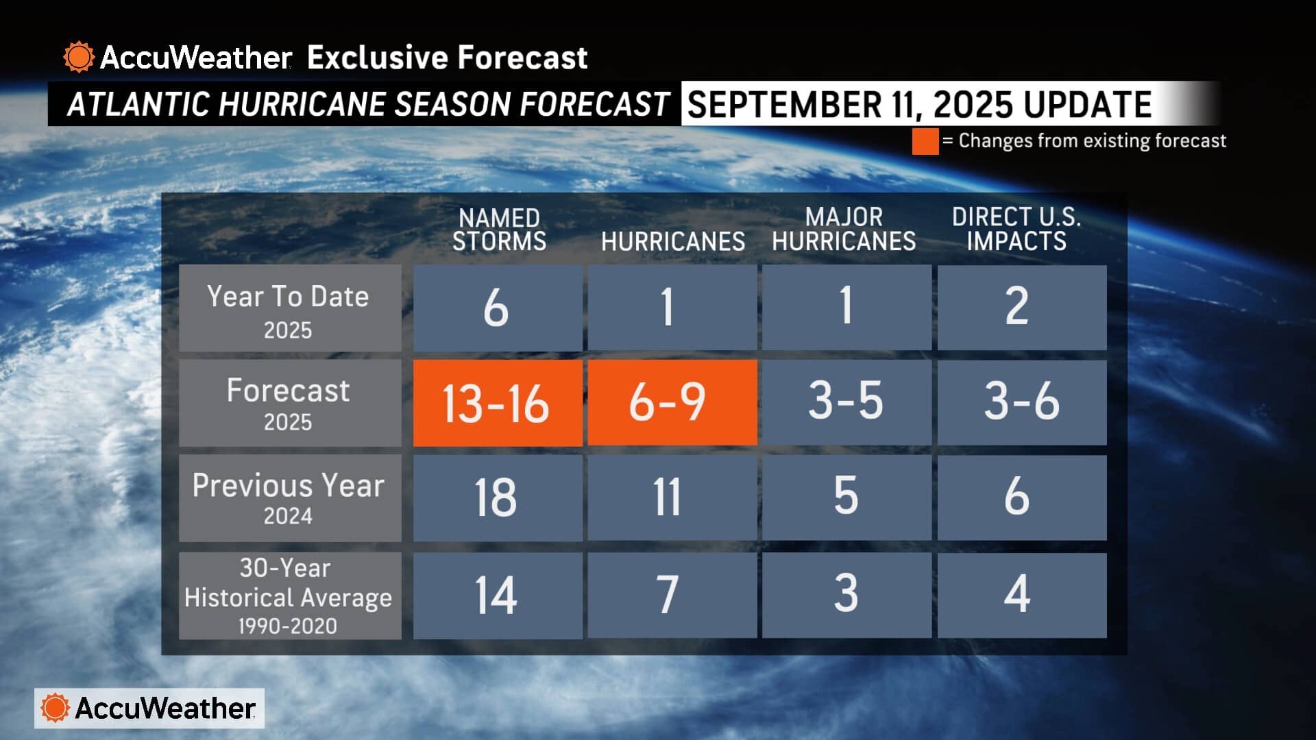
Following an unusually quiet stretch across the Atlantic basin during the climatological peak period of tropical activity, AccuWeather® hurricane experts are slightly reducing the forecast for the highest potential number of named storms and hurricanes expected to develop this season.


AccuWeather® now forecasts 13-16 named storms and six to nine hurricanes for the 2025 Atlantic hurricane season. This is the first update to the AccuWeather® 2025 Atlantic Hurricane Season Forecast, which was first issued in March.
“AccuWeather hurricane experts are constantly refining and integrating new data into our predictions,” AccuWeather® Lead Hurricane Expert Alex DaSilva explained. “Unusual surges of dry air, Saharan dust, disruptive wind shear, cooler water temperatures off the western coast of Africa, and other atmospheric conditions have hampered multiple tropical waves from developing into tropical storms or hurricanes, during what are typically the peak weeks of tropical activity in the Atlantic basin.”
The forecast for three to five major hurricanes and three to six direct impacts to the United States has not changed.
“The range of named storms expected to develop in the Atlantic basin this season has been reduced, but the risk of direct impacts has not changed. AccuWeather® continues to forecast three to six direct impacts to the United States this season,” DaSilva said. “It only takes one storm to create a devastating hurricane season.”
There have been two direct impacts to the U.S. so far this year. Tropical Storm Chantal caused an estimated $4 billion to $6 billion in total damage and economic loss, following damaging flooding and tourism losses in North Carolina over the Independence Day holiday weekend. Hurricane Erin brought rough surf, beach erosion and deadly rip currents to the U.S. East Coast in August.
AccuWeather® hurricane experts are urging people, businesses and officials near the coast and in inland areas that have been affected by hurricanes and tropical storms in recent years to remain prepared and vigilant.
“Please do not let your guard down or become complacent. The tropics have been unusually quiet during the typical peak weeks of the season, just like they were last year,” DaSilva said. “It is important to remember that Helene and Milton both developed well after the climatological peak of the season last year. Helene caused catastrophic inland flooding. Milton spun up dozens of destructive tornadoes across Florida. Helene and Milton claimed more than 250 lives and caused an estimated $385 billion to $430 billion in total damage and economic loss, according to estimates from AccuWeather.”
DaSilva said the exceptionally high water temperatures in the Gulf have increased the concerns for potential rapid intensification in the coming weeks.
“The heat and energy stored in the Gulf reached record territory this week. The waters are dangerously warm. This surplus of energy in the Gulf can act like rocket fuel,” DaSilva explained. “If a storm spins up or moves into the Gulf, and atmospheric conditions are conducive for development, these warm waters can support rapid intensification, and even cases of extreme rapid intensification. When a storm, like Hurricane Erin, strengthens with maximum sustained winds increasing 58 mph or more within 24 hours, it meets the threshold of extreme rapid intensification.”
- AccuWeather® hurricane experts continue to highlight northern and eastern portions of the Gulf Coast and the Carolinas as areas of higher-than-average risk of direct impacts this season. Atlantic Canada and the northeastern Caribbean, including Puerto Rico and the United States Virgin Islands, are also at an increased risk of direct impacts for the rest of the season.
- Inland areas far away from the coast will have a risk of flooding and tornadoes, just like in 2024. Parts of the Appalachians, especially from Virginia on south, could be at risk of experiencing flooding again this year. It is very important that residents even well inland from the coast closely monitor the AccuWeather® forecast, as tropical storm and hurricane impacts can extend hundreds of miles inland.
- AccuWeather® hurricane experts stress that now is not the time to let your guard down anywhere along the Gulf coast, Atlantic Seaboard, or inland areas that can face impacts from hurricanes, tropical storms and tropical rainstorms. It only takes one powerful hurricane or slow-moving tropical rainstorm to create a major natural disaster. The presence of such warm water, especially the record high ocean heat content of the Gulf, remain extremely concerning because storms that can take advantage of that “high octane” fuel. If certain atmospheric parameters are in place, a storm could rapidly intensify, perhaps close to the coast, and greatly amplify the danger, damage and impacts.
Advertise with the mоѕt vіѕіtеd nеwѕ ѕіtе іn Antigua!
We offer fully customizable and flexible digital marketing packages.
Contact us at [email protected]


